Winter 2008
These reports are done as time permits. Further information will be added to them periodically.
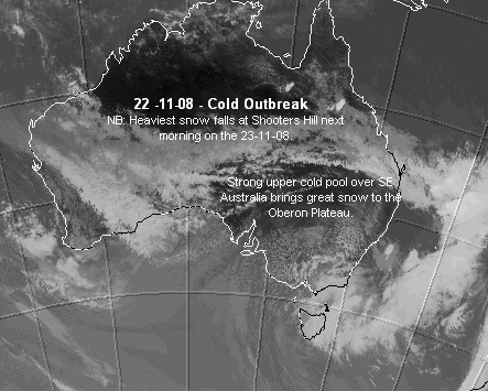
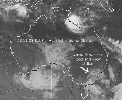
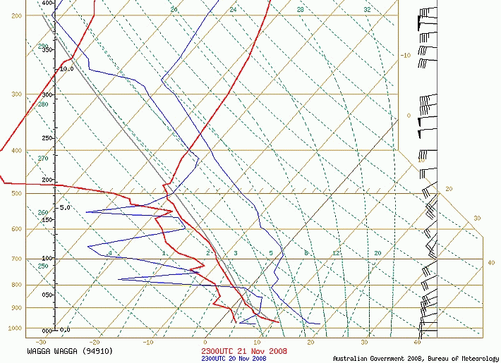
November 22nd and 23rd - 2008:
Its a little hard to believe that I am writing this report about such a great cold outbreak in late November. About a week ago, the charts suggested a nice cold pool would sling shot this way courtesy of a strong surface low. Its just that not too many weather folk believed such a scenario would actually happen! By 2pm Saturday passing cold air convective cells produced hail and then sleet showers in Blackheath that occasionally turned to snow flurries as well. At 2:30pm it had dropped to 1C and throughout the afternoon more hail/sleet and wet snow occured although it was usually only for five to ten minutes as more cold air cells passed over. At around this time the Wagga Wagga weather balloon sounding was showing the upper atmosphere at 500hPa to be -32C and -11C at 700hPa which is just incredible for late November. Things backed off a little in Blackheath that evening but by around 5:30am the next morning on the 23rd, more sleet and snow showers were occuring with the temp again around 1C. A phone call from an Oberon woman to ABC radio got me interested in a quick snow chase and before long I was wiping the sleep from my eyes and heading west.
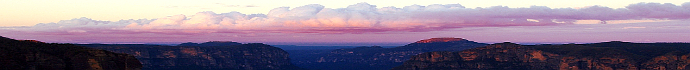
Rain turned to sleet at about Hampton and then by the time I reached the Mt Bindo turn-off, moderately heavy snow was falling with a sticky settling to about 1 or two cm. Arriving at Oberon township saw about 3 to 4cm on the ground and stuck to all of the trees. I was pretty excited about how much snow would be at Shooters Hill but the intensity of the snow falling only allowed me to get about 12ks along the Shooters Hill road before I had to stop for photos and then turn back. I have never seen snow that thick so late in the season, it was very impressive. I would guess 10cm at least at Shooters Hill, maybe a fair bit more under the heaviest cold air cells. Sure, such falls in November have happened occasionally over the decades but its a rarity indeed. I then drove back through Edith and up to Mt Trickett where falling snow was less intense but there was still about 4cm on the ground. I'll let the photos tell the story via the usual links but that was one very strong system for November.
October 22, Friday, 2008:
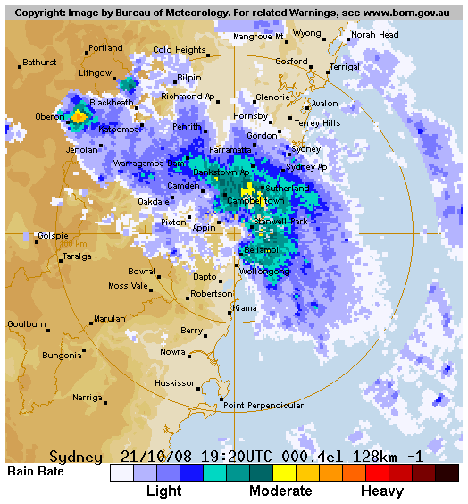
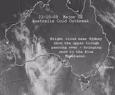
Well, this cold outbreak is definitely worth mentioning here as it was certainly quite strong for late October. Most of the forecasting models were showing a chilly outbreak but not a snowy one. Only the GFS model showed the upper trough cold enough to potentially produce snow in the Blue Mountains. It seemed more reasonable at this time of year to imagine a few flakes above 1200 metres on the Oberon Plateau but to see the snow that fell in the Blue Mountains was a welcome surprise. Hail started falling in Blackheath at about 5am on Wednesday morning and continued intermittantly until about 6am when sago snow and sleet commenced. There was also decent thunder at this time with some very bright flashes across the eastern sky.
By 6:30am wet snow was falling as the temp hovered around 1C. It continued to fall without much respite for about an hour and a half but the showers were only light to moderate at best over this way with little settling (0.5cm) due to the marginal temperatures. Coldest temp I recorded was 0.8C. The stronger convective showers were across the Oberon Plateau and then towards Mt Lambie where up to 5cm of hail and snow fell. You can see on the radar link above that the most intense shower activity was near Oberon. By 8:30am the snow was turning to sleet and then hail showers continued intermittantly during the day as it warmed up at the surface. The Sydney sounding for the day was around -26C at 500hPa, -8C at 700hPa and about 0C at 850hPa with the convective showers briefly lowering the 850hPa temps at times to allow snow to fall.
August 22, Friday, 2008:
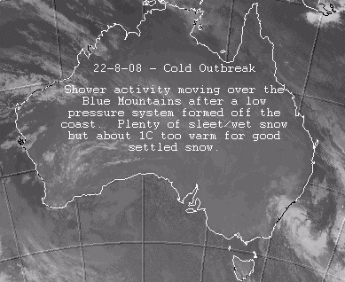
More added to this report as time permits. This event was looking fairly good on paper but the main concern was just how marginal it might be for the Blue Mountains. Plenty of moisture seemed to be available but the system was only just cold enough to produce snow in Blackheath. The BoM had snow down to 1100 metres and this pretty much turned out just right. At around 1pm on Friday a nice hail shower occured with hail to 5mm or so in size. By evening, the showers were gradually moving through and from about 9pm to around 2am there were continual sleet and snow showers in town. At times the snow showers were quite good but this system was so marginal that some lower places in town only saw sleet and cold rain whilst other spots had nice wet snow showers.
Mt Boyce is around 1100 metres ASL and some lower parts of Blackheath are only 1030 metres ASL. Where you lived made a big difference on this night. Laurier Williams from Australian Weather News drove around after midnight to confirm these observations. There was a light settling of about 0.5cm in my backyard on the Saturday morning. It was a bit frustrating as I recorded 8.2mm overnight and you could imagine how much snow we would have had from that if it was one degree colder. I don't think the Oberon area recieved large amounts of snow but I await more news on that. Guyra had a lovely settled fall - again! Part of this is related to how most of the cold pools this year have drifted NE and partly missed the Blue Mountains but also because Guyra is nearly 300 metres higher than Blackheath.
August 18, Monday, 2008:
This system was basically a prelude to the bigger system on the 22nd and not really noteworthy of a significant report but I will put it here for reference. Some hail and sleet showers occured in Blackheath during the afternoon but they were only brief. At just before 9pm that night very light snow fluttered down but unless you were keen, it would have gone unnoticed. Places like Sunny Corner had some settled snow from this event and the Oberon Plateau would have seen light snow as well.
August 10, Thursday, 2008:
The old creative writing student in me came out a bit with this report, so head to the last paragraph if you are short on time.
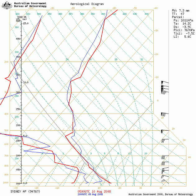
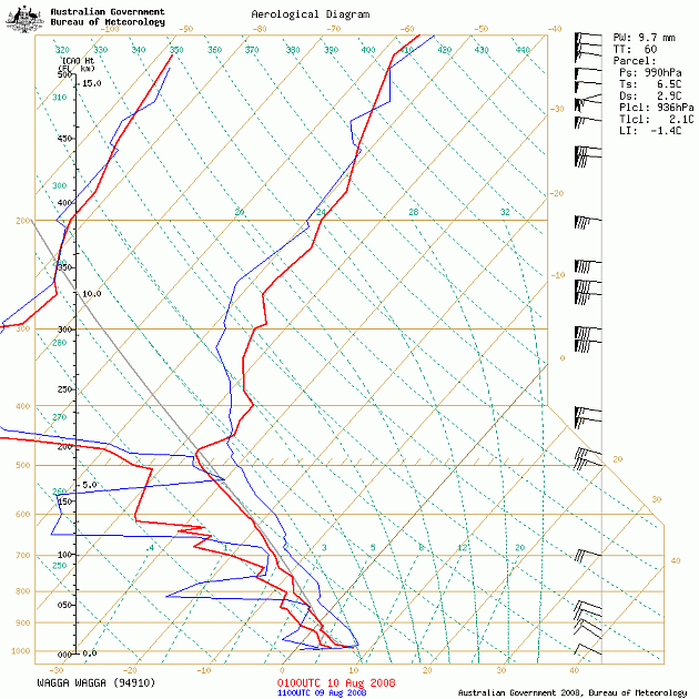
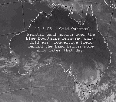
This system delivered nicely in the context of cold air and dry snow although accumulations were generally only light to moderate across the Central Tablelands. Sunday morning arrived with my mouse clicking through the models, sat loops and radar images. I was hoping for a big burst of snow showers over the Blue Mountains. A rattling window reminded me to look outside first as it was already snowing. Our first fall for the day was full of lovely big flakes that fell fairly regularly from roughly 6am to just after 6:30am with some light settling. This little fall came from a faint finger of instability just in front of the main frontal band, from what I could tell, so I was hopeful of better things to come.
I decided to wait and watch developments before heading out to the OP for a snow chase as I didn't want to miss some nice snow here. Tennis beckoned. My first serve let me down as usual. The morning was lovely and cold with a mate turning up to play a few sets in shorts and a t-shirt! Only problem was the shirt was inside out and the shorts were riding a little high. By around 11am we finally had the frontal band arriving (boosting my first serve to 70kph) with lovely snow showers falling for about an hour that eventually halted play. It was fairly heavy at times and started to settle but the snow then eased.
Back at home the satellite loop showed some handy cold air convection on the Oberon Plateau that had me grinning a little and squirming in the k-mart swivel chair. Andrew Miskelly had sms'd me about the conditions out there and the snow depth didn't seem too problematic for my 2WD. Laurier's post about heading out there on Weatherzone forums sealed it for me, so before long I was out the door with the k-mart swivel chair spinning like the ECL of '84 in my wake.
A quick stop at the local servo for some petrol and Smiths Chips (and the obligatory head wobble as I showed off my snow forecasting knowledge to my servo mate) saw me heading down the highway in the wrong beanie - the pjs and uggs boots one, instead of the fashionable one I bought on the same day as the swivel chair. There were some nice views out west as I headed down Mt Vic Pass which gave rise to a little smile and another gob full of chips in between third and fourth gear.
Reaching the Mt Bindo turn-off saw me take the first gamble of the trip - the second was a master overtaking move on Matt Pearce on 'Shooters Straight' just before the hill turn-off. I was now confronted with a convoy of sight seers moving slower than a Ginkin School bus. I know these roads pretty well so wisely (add sarcasm here), I let four cars turn right towards Oberon and felt happy with my decision when only one 4WD remained ahead of me on the Jenolan Caves road. A nice clear run to the caves for sure...About 30ks later that four wheel drive finally saw me sitting behind them and waved me on, by which time I was leaving Caves House, had read War and Peace, performed minor surgery to a mole on my face and learnt a second language...and then taught it to thirteen School Of The Air students in Megalong Valley via my mobile.
Arriving at Mt Trickett, the snow cover had quickly thickened to around 2 to 3cm or more and on my way down to Edith the snow was really piling down. I was a little nervous of just how thick it might be at Shooters Hill but curiously there was less snow on the road heading up that way. I pulled into the Shooters carpark, easily beating Matt and Erin to the finish line. There was only a few cms at most on the ground but the winds were howling and so was Matt after copping a mouthful of wet snow as I overtook him moments ago. He spat that snow back at me as he shook my hand but it tasted quite good, considering where it had been.
Matt Smith shook my hand and frowned painfully (just like he does when QLD looses in State of Origin) as he looked at my 'bedroom beanie' with more pills on it than a Chemart counter. I deepened my voice and added another head wobble but it was too late, the 'bead-room' beanie was going down in chaser folk lore as the fashion faux pas of the decade. The two Matts and their lovely wives decided they had had enough of the cold and wind and choofed off to warmer climes, which left Andrew and myself and a few other ring-ins, to make the most of the snow and wind. We soon took off for a lap of the area and Andrew showed me a lovely spot nearby where some crystalline drift snow had settled down for the evening, in incredible layers of undulating softness. Talcum powder snow for sure.
We eventually headed back to Shooters Hill and sat there and watched the rime accumulate and coldies move in. An excellent chin-wag was had for quite some time in the warmth of Andrew's Hilux cabin. Soon the day darkened under a setting sun and a little more cold air convection, so we shook hands and parted for our respective towns with a toot and a 'cheerio'. Those coldies really starting picking up on the way home too, with Andrew reporting quite heavy snow showers on his trip south to Goulburn and a similar experience was unfolding for me. It was even sleeting strongly at Caves House and I think Laurier Williams from Australian Weather News reported some settling snow there a bit later on. The trip in and out from the caves was a bit tricky as ice was all over the roads as well as a crusty cover of snow. My back-end slid out two or three times but such was my slow speed (I was praying that 4WD was stuck behind me on his return trip) there wasn't too much trouble in the end.
Back in Blackheath that night we had more intermittant snow showers that brought a light, crunchy cover. Our town on Sunday saw nice snow showers at 6am to 6:45am, 11am to midday and around 3:30pm to 4:30pm with a light settling each time. Next morning we had a crackly, light cover across the whole yard. So, this system was cold indeed with our max temp on Sunday in Blackheath not quite reaching 4C and for the most part it was closer to zero. Sadly up our way, we didn't really see great 700hPa moisture (a bit patchy) and the instability was generally isolated. The Oberon Plateau scored a little better overnight and I could see the light to moderate cover across Mounts Bindo and Trickett this morning.
August 7, Thursday, 2008:
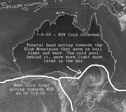
This event turned out quite like the models predicted, a nice frontal band with some hail, sleet and snow and then the cold pool behind it bringing a bit more snow. Blackheath started the day with quite mild temps in the prefrontal NW winds and by midday we were just over 8C. By 1pm it was dipping below 3C at my place with nice soft hail showers and sleet soon to follow. From 1:50pm to 2:15pm it snowed nicely in town with the snow showers really pelting down at times. It dropped just below 1C during the snow. A very light settling occured but it soon melted. Later that night at around 7:40pm it again snowed nicely for around twenty minutes and I could hear the men training on the local footy field cry out with delight, or was that annoyance? It dropped to about 0.5C at this time. By morning we had mostly strato cumumulus clouds with little vertical extent that produced very light, spitty showers.
The Wagga Wagga weather balloon sounding for the morning of the 7th showed the temperature profile as follows: -29C at 500hPa, -11C at 700hPa and around 0C at 850hPa. So, we can see how unstable the atmosphere was and the vertical mixing that occured to bring us the icy precip in the afternoon, as the frontal band passed over. Later on that cold pool moved in with less moisture and brought some snow again. The usual spots like Oberon Plateau and Sunny Corner etc saw nice settling snow to a few cm.
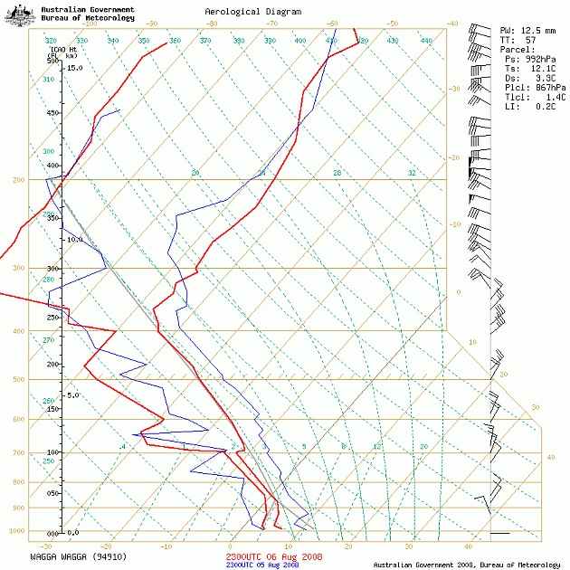
August 6, Wednesday, 2008:
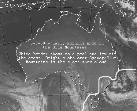
A bit of a surprise overnight with the lower levels just getting cold enough to produce 5mm of sleet and snow in Blackheath. The temp dipped just below 1C overnight so the snow showers were quite nice at times. The Sydney sounding this morning shows 500hPa temps of around -26C, -8C at 700hPa and about 0C at 850hPa, so we were quite lucky to see snow from that setup. Most of it has melted now as it turned to sleet by daybreak. View the satellite image above to see the cold pool over the Blue Mountains, more details as time permits.
August 1, Friday, 2008:
This is a preliminary report and will be updated soon. Well this system wasn't expected to pack much punch this far north but it probably pushed a little further our way than the models predicted. Perhaps the tight thermal gradient at 500 hPa that was mentioned on Weatherzone forums enhanced the winds as well as the pressure gradient at the surface. Blackheath had strong winds moving into the afternoon and evening with Mt Boyce recording 96km/r at 11pm. Locally, with our variable topography, there could have been gusts stronger than that. There would be some large branches down for sure this morning (Saturday) and maybe even some old trees as well. Some cold rain with specks of ice in it started falling after lunchtime and sleet was occasionally occuring in town by 6pm but no snow. I recorded just over 4mm in my home office gauge. Portland had a wonderful hail shower that totally covered the ground on Friday evening and no doubt the Oberon Plateau would have had some snow settling up high above 1200 metres. Apparently Ben Lomond had snow again on the Northern Tabelands on Friday night but the extent of this will be confirmed as the details come to hand. This report will be completed as time permits.
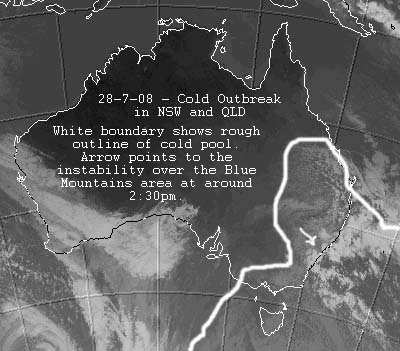
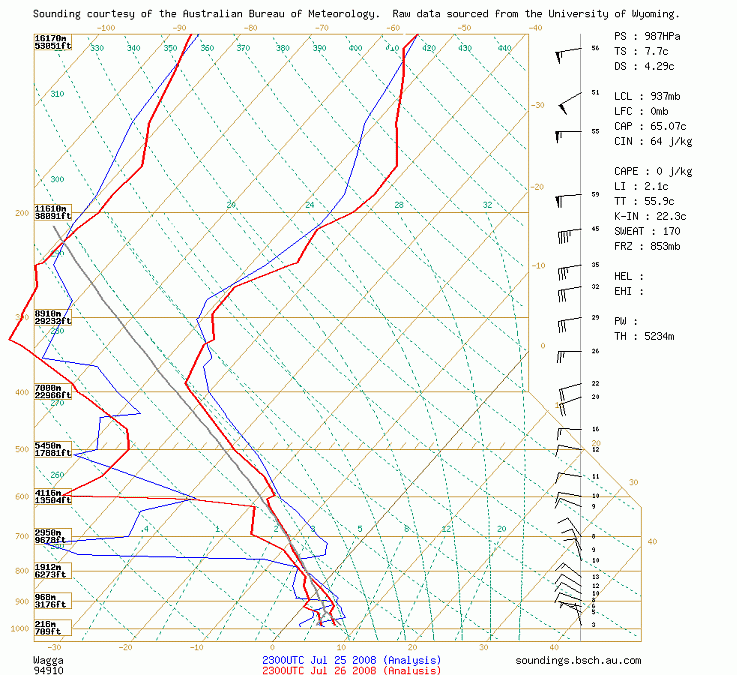
July 27th and 28th, 2008:
The soundings links here will help you see just how cold this air mass was in reality. View the Thunderstorms Forecasting Guide below to learn more and read parts 6 to 9 on Skew-Ts, if you are technically inclined.
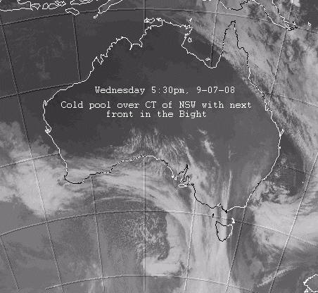
NB: This report is still being developed so more editing will be done soon. This event showed promise for more than a week out but we were waiting to see how the upper cold pool would influence surface patterning and indeed how extensive this cold pool would be. There have been precious few classic cold fronts this winter and the vast bulk of cold systems moving over Australia have been cold pool setups. That is, rather than a large wave of cold air passing over SE Australia, we have had these relatively small cold pools in the upper atmosphere, which makes it quite hard for forecasters to predict just where these cold pools will go. It seems the prevalence of upper cold pools this season is related to the sea surface temperatures in southern Australia and also in the Tasman Sea but there would also be other mechanisms involved, that could possibly be connected to climate change. That is, perhaps the frontal systems are fragmenting more as they move north and smaller, less impacting cold pools might become the norm. Its hard to say.
By Saturday night it was clear this system had quite a strong upper cold pool with temps at the 500hPa level in the atmosphere at around -28 to -32C forecast. The other encouraging thing was that this cold pool was quite extensive. By Sunday afternoon the leading edge of this upper cold pool was moving across the Central Tablelands and some light snow showers were occuring on the Oberon Plateau. Even though the air mass was cold indeed (see the Wagga sounding above) it seems that mid and lower level moisture was a bit patchier than the models forecast so the snow showers were somewhat isolated. Add to that, in spite of the very cold mid and upper level temps with this system, temperatures closer to the ground (just above the Blue Mountains altitude) were not that cold at only 0C. We had sleet here in Blackheath for around fifteen minutes at 3pm but no real snow was observed. Mt Victoria had some snow showers in the afternoon and so did a number of other spots including Oberon, Milthorpe, Rydal, Sunny Corner, Lithgow, Portland and even Bundanoon in the Southern Highlands. If you were lucky enough to be under a stronger shower cell, then snow was a pretty good chance as the cold air mixed down briefly from the higher levels of the atmosphere.
By Monday surface winds were turning more southerly and then south easterly as a low formed off the east coast. Our temperature in town hovered between 2C and 3C for most of the day but maxed at 4C briefly. Blackheath did see plenty of sleet showers (6.5mm worth) from about 11am to 6pm but only a few minutes here and there of snow in stronger downdrafts. By now the upper temps had warmed a touch but were still quite cold and even extended into QLD but the air mass down lower was not super cold. The Sydney weather balloon sounding for Monday showed 500hPa temps of -28C, 700hPa temps at -9 and 850hpa temps of around 0C. For a really cold air mass I like to see 700hPa temps at around -10C or colder and 850hPa temps of around -1 to -2C at least. The 850hPa temperature roughly resides at about 1400 to 1500 metres above sea level so that is about 300 to 400 metres higher than the town of Blackheath. This height in the atmosphere is a good guide to how cold it might get at our level as its not far above us. This air mass was quite moist too so zero degrees at the 850hPa level would roughly convert to about 2C in the town of Blackheath - give or take a degree, depending on whether we had clearish skies or cloud and showers. It can be a bit more complex than that but I don't have time to go into all of the details now. NB: The Williamtown sounding (see link above) was indeed a bit colder so I imagine places like Barrington Tops would have seen excellent snow.
In short, this system on Sunday was very cold in the upper and mid levels but not super cold in the lower levels with patchy moisture, so you had to be right under a strong shower cell to see snow. On Monday the moisture was better as winds swung more onshore but the lower temps still remained just a touch too warm to see snow at our altitude. There were more shower cells around but we had mostly sleet across the CT unless you were above around 1200 metres because of the lack of lower level cold air. South easterly winds typically have a very moist air flow which usually requires the temperature to get down to at least 1C before we see snow here in the Blue Mountains. It just wasn't quite cold enough in the lower levels for that to happen. Add to that, Blackheath was a bit unlucky with those isolated, stronger showers as a number of towns and places had snow overnight Sunday and into Monday but not us. That's life, Blackheath has had plenty of 'lucky' falls over the last ten years and this time the luck went to other places.
July 21st, 2008:
This Monday event showed a bit of promise but in the end Blackheath only had brief sleet and hail for five minutes just before midday. Katoomba and Lithgow also had similar sleet and hail showers and no doubt the Oberon Plateau would have had some light snow. It was very cold and windy with wind chill temps reaching about -6C but that was about it. The two days following have seen great frosts though with -2.9C and -3.1C respectively.
July 9th to 11th, 2008:
Well, winter took a while to get going as far as cold fronts are concerned but it finally gave us something to crow about. Whilst the upper temps (roughly 5000 metres above sea level) of the first cold front on Tuesday were quite cold, surface pressure patterning was quite high (stable air, not much air rising up to form solid snow bearing clouds) so this usually means snow mostly for the western areas of the tablelands in places like the Oberon Plateau, Sunny Corner and Orange etc. As the front moved north, the Oberon Plateau is the the first high point that the cold airmass encounters so as its lifted over the ranges there any snow that is available usually gets squeezed out of the clouds before it reaches the Blue Mountains. The Blue Mountains tends to get the dregs in this context, that is, cloud breaking off from the main bank of clouds over the Oberon Plateau. For better snow here in the BM we need low surface pressure AND cold upper temps or preferably cold winds from the south as the Oberon Plateau doesn't block us from that direction.
It started snowing here in Blackheath on Wednesday morning but only from cloud breaking off from the Oberon Plateau, so it was light snow only and soon turned to sleet by 9am. Surface pressure was quite high so not many clouds were forming to enhance snowfall but there was sufficient moisture in the mid levels (just) to allow a little bit of snow and sleet to fall throughout the day. From around 4pm to 5pm steady sleet showers fell and then from around 6pm onwards we had another band of solid sleet showers falling with very slight accumulations but no real snow. The Oberon Plateau had snow overnight Tuesday and into Wednesday with a few cms in Oberon township and Orange also had a nice settling of a few cm. This snow melted fairly quickly as I headed to Oberon and Shooters Hill by midday when most of the snow was gone. We did experience some lovely snow showers at this time. The Northern Tablelands also had some lovely snow showers during this event with Guyra getting a number of cms settling in the town for the second time this year. A great result for them.
By Thursday morning the next front was moving in with strong gusts over 80kph and persistently over 50kph. The upper temps were not as cold in this event but surface pressure was a little lower and lower to mid level moisture was slightly better than the previous front. The apparent temperature or windchill temperature got down to around -11C during Thursday. There wasn't any sleet or snow to speak of in Blackheath until the evening when light sleet then snow started falling at around 10pm. Some snow showers occured for a few minutes at 10:45pm. It also snowed lightly and settled briefly from roughly 12:30am to 1:30am on Friday morning. By daybreak on Friday there were light sleet and snow showers falling from around 7:30am unil 9am when they eventually turned to light spitty rain. As the day went on, the cloud broke up as pressure rose more at the surface and the rising sun came in from the east. The Oberon area again had a few cms of snow in the higher areas above 1100 to 1200 metres and Sunny Corner also had about 2cm of snow on the ground by Friday morning.
So to summarise, it wasn't a super event with low pressure at the surface and strong cold air cells passing over regularly bringing great snow but it was a fun event in the context of a slow start to winter. The Oberon Plateau and places like Sunny Corner will usually do better out of events like this, when surface pressure is quite high. Hopefully there are not too many typos in this report. I usually produce such reports in the middle of very busy times.
May 17th and 18th, 2008:
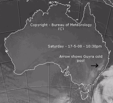
NB: See photos of this event in the menu link at top of page. This event was shaping up to be more productive for the Northern Tablelands of NSW rather than the Central Tablelands and this came true in the end as no snow fell in the Blue Mountains. We had some hail (which is very different to sleet) and cold showers and strong winds but that was all. Certainly great news though for those north of us as they had some ripper snow there. A week out from this event most forecasting models were showing a cut-off cold pool scenario and as I have mentioned over the years, this type of cold outbreak is hard to predict as the cold pool can move about in the upper levels, be quite small and make life generally difficult for forecasters. Eventually the models came to a general agreement on the look of this system although some predicted a stronger low forming off the coast than actually occured. The lack of particularly warm sea surface temps off the east coast may have been a factor in this regard as well as the cold pool not moving that close to the coast but staying inland a little.
The upper cold pool generally moved across NSW on Saturday and brought decent snow to the ski fields in its wake. As it continued north towards our area it fragmented a little and the coldest portion of the cold pool pretty much moved towards the northern tablelands and missed the Blue Mountains and even the Oberon plateau, although some snow fell there but didn't settle a lot. You can see on the satellite image above that there is a cold pool (blob of cloud) below the Guyra one. This is the cold pool that stayed mostly west of the Central Tablelands and the Blue Mountains.
Andrew Miskelly, the Weatherzone Webmaster and also a pilot produced this explanation below over at Weatherzone forums and it helped me understand why the Guyra area received so much snow even though the lower levels were not that conducive to it falling. NB: And don't forget Andrews personal site here.
"...heavy snow falls from the cloud and melts, absorbing energy from the surrounding atmosphere in the process. This allows subsequent precipitation to remain as snow to lower and lower levels.
It makes sense that for this to be effective to any great extent you need relatively heavy, persistent precipitation. While cold-air down-draughts from showers can be effective in momentarily bringing snow to lower levels it doesn't tend to result in significant settling.
It tends to be the case when this goes on that the lapse rate close to the surface is pretty flat. Last year I drove from Shooters Hill (1350m) to Taralga (850m) in constant, heavy snow and the temperature hovered around zero the whole time.
This process can be useful in bringing low level snow when fronts pass in the morning and the near-surface air is already a few degrees cooler than it might be during the afternoon.
It's also almost exclusively how places like the Southern Highlands (around Bowral) ever get any snow - the combination of a moderately cold atmosphere and a fat rain band."
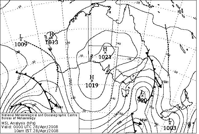
April 28th, 2008:
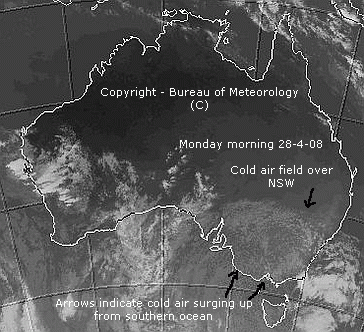
Well, what a day this was. I will try to fill in this report as time allows over coming days, suffice to say, in some ways, it was one of the most impressive fronts ever to arrive in April. Sure, there have been snowier fronts in April on rare occasions but not many of them at all in recent decades. The most impressive aspect of this system was that the upper temperatures were so cold. -31.9C at 500hPa is an April record by more than 4 degrees! Its also the equal lowest temperature at that level (for any month) in the atmosphere since 1993. I'm quite sure this applies to NSW only but will confirm this as I get time. Temperatures lower down at the 850hPa level were the third coldest ever for April, which whilst not quite as impressive, is still very good indeed.
Blackheath had four seperate periods of snow shower activity throughout the day, the first one at around 1:30pm and the last at around 5:30pm. One of these snow showers at about 3pm lasted for more than twenty minutes and was quite intense at times. No real settling occured here as the temp was around 1C for most of the time during the snowfalls. Places like Sunny Corner had settled snow to about 3cm and the Oberon Plateau had notably more than that. Portland also had snow showers, quite heavy at times. That's all I have for now but this event would be considered good for winter, not to mention April. Not huge amounts of moisture but the system as a whole was very cold and impressive for this time of year. Katoomba looks to set an all-time April record for lowest day time maximum as well - to be confirmed. NB: Katoomba came in at 7.8C for their maximum yesterday (the April record from 1982 is 7.2C) but I can't work out how they were 2.8C warmer than Blackheath yesterday, even allowing for less cloud or snow. BTW, our maximum at Mount Boyce AWS yesterday was a new April record at 5C.
Some more of the sites in the central tablelands that recorded their coldest ever maximum temps for April are Bathurst AP (8.6C), Mudgee AP (12.5C), Oberon (4.5C), Orange (6.4C), and Wellington (13C). The temperature records for Wellington go back 88 years so setting such a record is very significant. Taralga, in the southern tablelands, and just to the south of Oberon also set a coldest ever maximum record (7C) and their temp records go back 47 years.