Winter 2011
September 29th, 2011:
Not really a geniune cold outbreak in a snowy context but its probably worth mentioning here. Wind gusts reached 98kph at around 1:30pm on the 29th and also 93kph at 3:30am on the 30th. Hail fell yesterday in Blackheath and at times it was quite intense. Melting hail can be confused with sleet although it usually falls at temps of around 3C to 4C or higher. It also looks different as it falls in showers, compared to sleet or snow. The temperature did drop to 3.7C at 3:30pm under heavier showers and also dropped to 2.5C at around 9pm. We had a few very brief moments of sleet last night in Blackheath around 9pm but no snow. Sunny Corner reported light snow at around 9pm, that settled to about 1cm. As far as I know there was little snow on the Oberon Plateau although I'd imagine light snow showers would have occured above 1200M at some point.
September 9th, 2011:
A much anticipated event after such a long time since our last outbreak but sadly it didn't deliver a great deal. The models were chopping and changing a lot in the week or so leading up to this event and even a day before it arrived there was still disagreement on the charts. Then the night before the event, the models were stronger and remained strong the next morning, just before the system arrived. Unfortunately, the forecasted cold uppers didn't really produce much this far north as it seems the moisture was fragmented over the Central Tablelands and also instability wasn't widespread. This system 'ridged out' quite quickly as the surface high pressure system moved in and subsidence occured.
The rainband early Friday produced 12mm, which mostly fell from daybreak to just before 9am. There was some sleet and hail and snow pellets in Blackheath by mid Friday morning the 9th but this was mostly when it was quite mild (about 3C to 4C) as the precipitation was falling in relatively dry air. As soon as the lower level RH went higher with the showers, the sleet turned to cold rain. Again in the evening, there was a little sleet but not much. Some light falls occured on the Oberon Plateau but not a lot more than a dusting. The Northern Tablelands and Barrington Tops did better, being higher and exposed it seems to the best instability. A few cm occured across the higher parts of the NT and even more than that at Barrington (up to 7cm) where the higher ground there makes it easier for snow to settle.
July 19th, 2011:
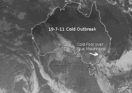
A nice little event today with a fairly concentrated cold pool moving up the coast and delivering sleet and snow to numerous areas. A surface low is now developing off the coast of Sydney and introducing warmer air in the mid and upper levels, so snow will be mainly replaced by sleet and rain as of 6pm. The Southern Highlands saw sleet and some snow and plenty of towns across the Central Tablelands saw some settled snow, including Blackheath. Even the Northern Tablelands had some snow showers and light settling around Walcha. It didn't get quite cold enough during the best precipitation to produce good settled snow in Blackheath (about 1cm or less) but places like the Oberon Plateau and Yetholme saw up to 8cm. More information as I get time and it comes to hand. This event certainly wasn't a classic cold front setup but cut-off cold pools floating NE can produce handy snow at times.
July 5/6, 2011:
No snow here in Blackheath for this event except for a bit of sleet but the winds peaking at 139kph (and possibly up to 150kph on exposed western edges of town) certainly make it a worthy weather event for this page. Oberon had some snow showers and there was some very light settling on the higher areas like Shooters Hill and Mt Trickett.
Of course, the main factor for many trees coming down in Blackeath was the extreme winds. No matter how firmly rooted a big gum or pine might be, winds in the 140kph to 150kph+ range can knock anything down. I've been chatting to a couple of plant scientists that know a lot more about trees than I do and root rot (phytophthora) can certainly aid in bringing down trees in our area. Radiatia Pine are also classed as a medium density softwood and this can mean they are less able to withstand strong winds compared to native trees at times. Also, gum trees can sometimes have problems establishing a deep root system, if a thick layer of rock beneath the tree was present. The main culprit was the strong winds it seems but keep an eye on trees with potential root rot, shallow roots or low forked trees too, where weakening can occur.
NB: Its sad to hear of many folk in Blackheath still without power after nearly four days now, see this story.
I haven't had time to assess this event in detail but Laurier Williams from Australian Weather News has given some fascinating insights. Below are some of them, originally posted on Weatherzone forums.
His initial thoughts on the 5-7-11.
1. The trough that caused the winds was always known to be vigorous, and had already caused isolated gusts over 100km/h at inland locations in TAS, VIC and NSW, though nothing on this scale. Looking at the hourly synoptics on my own site, there was a very strong compression of isobars during and behind the passage of the trough over the BMs, probably partly the result of forcing mechanisms caused by the mountains themselves.
2. The topography of the BMs puts the ridge from Katoomba to Mt Victoria perpendicular to the westerly windflow.
3. The venturi effect in the area is considerable because airflow is constricted by vertical cliffs and deep valleys. It helps explain the different experiences of our friends in the valley (which became a funnel) and just behind the cliff top (where the wind went over the top of them).
4. The speed that the trough itself was moving seems to have been around 50-70km/h which contributes to the total windspeed on the ground.
5. The core of the upper jet was just north of Sydney this afternoon running at 170 knots at 300hPa, and there was progressive mixing down of these higher speeds to lower levels. The 4pm GFS analysis for 850hPa winds (i.e. at about 1450m or 400m above the ridgeline at Blackheath) shows an area of 60 knots from the BMs south to around Moss Vale.
Then some more added later in the forums yesterday:
'I had a long discussion with a friend, Don White, who some of you may have heard of, about the causes of last night's extraordinary events and he had separately come to the same conclusions as me - i.e. a freak combination of events - mixing down of 170 knot jet core, localised strong pressure gradient, plus the usual channeling caused by cliffs and valleys that are part of any strong wind event in the mountains. The 18z GFS run still has the jet core at 300hPa running at 170-180 knots over Sydney with the inevitable mixing downwards. However, although the 850hPa winds (i.e. about 1450m asl) over the mountains are forecast to be around 55-60 knots, the 700hPa winds are lighter suggesting a decoupling from the jet that didn't exist last night. Also the forecast pressure gradient is not expected to be so great, though localised mechanical forcing caused by the topography of the BMs may not be reflected in this'
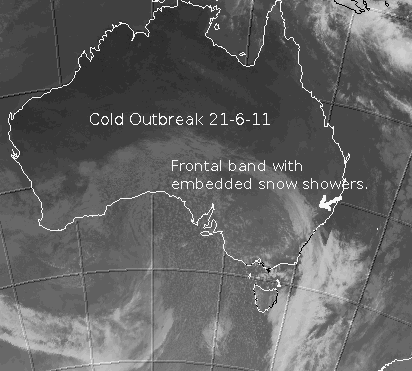
June 21/22, 2011:
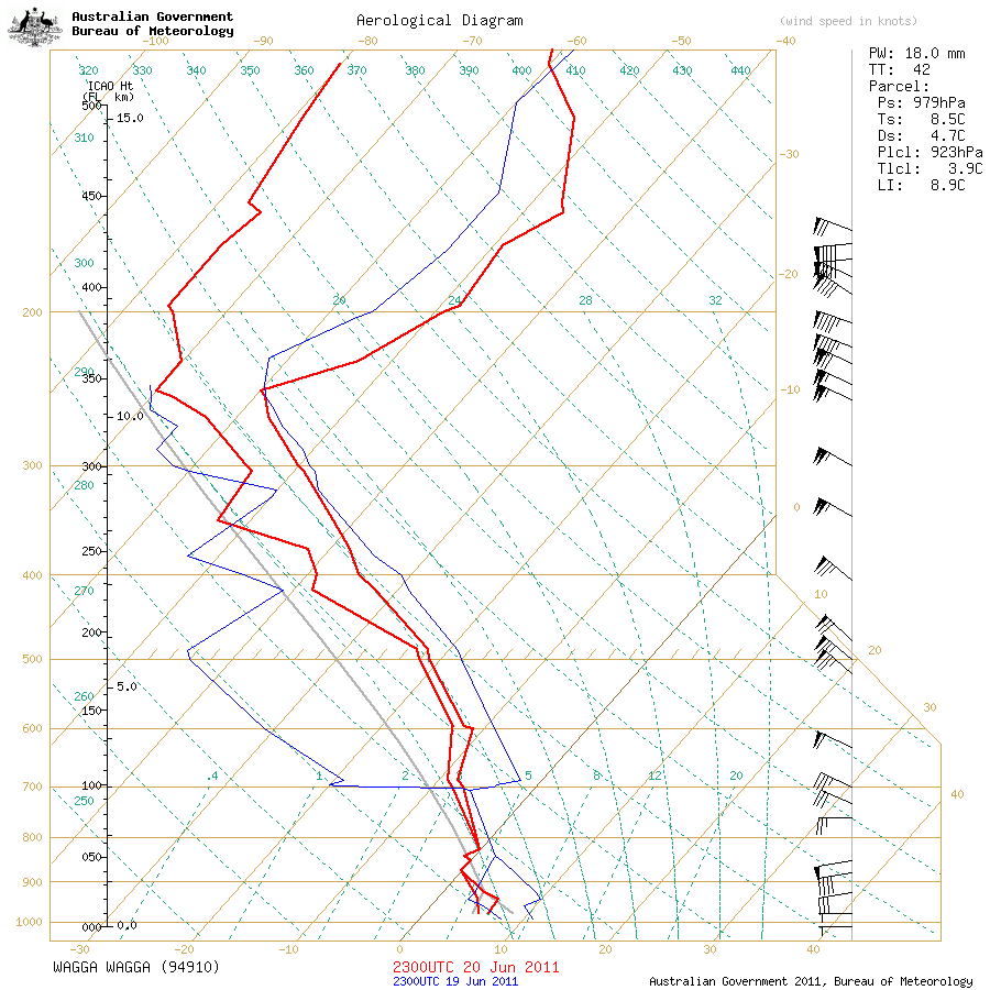
This event turned out better than expected. It started sleeting at around 2:30pm on Tuesday the 21st and then continued to snow until after 5pm. The snow was never heavy at my place but it was persistent, with moderate snow showers at times. The strong wind shear throughout the atmospheric layers helped mix down every bit of this cold air mass - see the sounding link above for wind speeds and more. Its a fine example to bust that long held local myth that wind prevents snow from falling; its actually needed to allow snow to fall, for cold air advection and mixing.
Even though the weather balloon sounding showed 500hPa temps that were quite mild, we still did well at the surface with 850hPa temps staying cold enough for snow. It was only about -22C at 500hPa which is very mild and about -7C at 700ha which isn't very cold for a snowy air mass. The atmosphere was also very moist which helped it warm at a slower rate as the air descended from 500hPa to 850hPa (saturated adiabatic lapse rate) so it didn't need to be that cold in the uppers or mid levels to keep the snow 'alive' all the way to the surface.
Add to that, the frontal band where more moisture is available, was actually cold enough to produce snow in the upper Blue Mountains, something that hasn't happened often in recent years. Often, we have to rely on the more isolated showers in the cold air convective field that follows the frontal band, to bring us light snow.
An unusual snow event for Blackheath, we got very lucky in many ways. Even the cold air cells embedded in the frontal band, were hovering right over us, so it all blended together perfectly. Katoomba didn't see much at all. Even the more eastern areas of Blackheath only saw a dusting whilst my area had nearly 5cm. Marginal snow cells tend to taper off across the highest, south parts of Blackheath and fade as they move eastwards into the lower parts of town.
These reports are done as time permits. Further information will be added to them periodically.
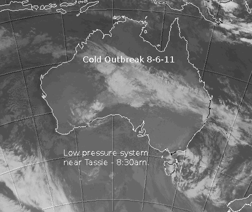
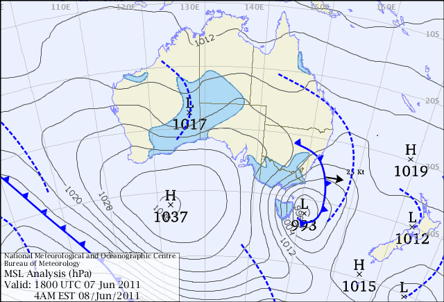
June 7th, 8th and 9th 2011:
This event was not very snowy but it was very cold, when you combine temperature and wind chill. Even the ski fields didn't get a lot of snow out of this system but it will provide good conditions for snow making. Tuesday the 7th was a very cold day in Blackheath with a minimum of around -1C, with the maximum temp only briefly reaching 4C. At 10am, it was still only 1C and by midday the temp had risen to 3C. Wind chill throughout the day hovered mostly between -4C and -7C and reached a low of -8.6C at 1pm. Peak gusts appear to have been 70km/h at 10:30pm.
Wednesdsay saw our minimum temp again hovering around -1C with a maximum of only 2.8C with wind chills again going below -8C. Virtually no precipitation in Blackheath on this day and only a few light flurries of snow on the Oberon Plateau and Sunny Corner. By Thursday it was 'warming up' and Blackheath climbed to a balmy 6C after a minimum of 0C but again, no snow. Sunny Corner had a light settling on Thursday morning and I'd imagine places high on the Oberon Plateau would also have seen some snow.
This system sure had the cold but there wasn't much moisture associated with it and it wasn't particularly unstable either. You can see by the MSLP analysis link above that surface pressures were not particularly low up this way. The surface low stayed well south, east of Tasmania, for most of the time.
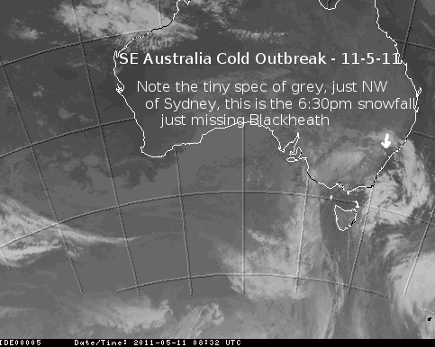
May 11th, 2011:
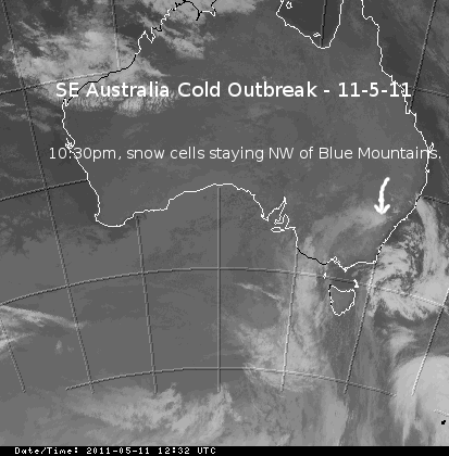
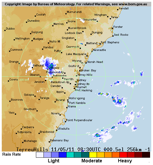
What an event this turned out to be for the Central Tablelands of NSW. Sure, the main supply of moisture early and later in the evening on the 11th just missed the Blue Mountains (see sat/radar images above) but it was an excellent result for Sunny Corner and Milthorpe with around 12cm and 7cm respectively for those areas. Mt Victoria was very lucky as they seemed to be right on the southern edge of this moisture band that gave them a nice settling at around 6pm (see radar image above) to maybe 3cm or so. Please confirm Mt Vic folk if it was more or less than that. I could only have a quick glance as I drove through.
Other factors for this event were the presence of a good southerly jet (strong winds around the 300hPa level) acting like a conveyor belt of cold air, feeding into the cold air cells across the central tabelelands and also ample instability via quite high Total Total readings, go to the Weatherzone Glossary to learn more about Total Totals, if you are interested.
The Wagga sounding for around lunch-time on the 11th showed reasonably good 500hPa temps at around -26C and the 700hPa temps were exceptional at around -13C. 850hPa temps were about -1C to -2C, so the middle levels of the atmosphere were nice and unstable with good moisture. The Sydney sounding this morning (12/5) is showing about -26C at 500hPa, -9C at 500hpa and around -1C at 850hPa.
So whilst the upper Blue Mountains folk may feel a bit dissapointed, the system as a whole, was very good for May. We just needed that moisture/cloud moving through later in the afternoon and then evening to be concentrated a touch further south than it was and we would have seen maybe 5cm or more on the ground in Blackheath. Shooters Hill and Mt Trickett actually had no more than Mt Victoria as of 7pm on the 11th as they appeared to be a little south of the main concentration of moisture too. I could see this occuring on Wednesday afternoon, with more moisture heading a touch north. Apart from a bit of bad luck yesterday for Blackheathens, the SW areas like Orange and Oberon tend to do better in a SW outbreak anyway. The upper Blue Mountains tends to favour southerly outbreaks which are rarer.
The Mt Boyce AWS recorded a maximum of 5C yesterday and it got to -0.2C this morning up there. So, cold enough for more snow for our area, if only that moisture swung a bit further south.
NB: Wednesday's maximum of 2.7C in Sunny Corner was lower than the coldest maximum for the whole winter of 2010, which was 3C. There is good evidence to suggest this was the heaviest early fall at Sunny Corner in known history, possibly in the last one hundred years. Will look into this more, thanks to snowmi from Weatherzone forums for the info.
Nice story from Weatherzone on this event here.
Below - some more technical stuff that might interest some of you.
From Laurier Williams, on Weatherzone forums 11-5-11, talking about snow forecasting and model grid points: 'Models divide the world into a grid of points and on each run they calculate the interaction of weather variables from now into the future across this grid in a series of steps. The spacing between the points for the current public GFS is ~35km, ACCESS Regional is ~37.5km and ACCESS Global is ~80km. You can actually see the grid if you look at a forecast wind chart - the points that the wind barbs fly from are the grid points.'
'The elevation in the model for each grid point is the average elevation of its surrounding area. So if your town was on a mountain top at 1000m surrounded by flat country at 300m, the average for the grid point nearest your town would be, say, 500m. Some model outputs for point locations obviously make more of an effort to correct for this, both by interpolating between grid points and correcting for the difference between the grid elevation and the known point location elevation. If the point location model output is half-way decent, it will give you the elevation, latitude and longitude of the point for which it's forecasting, and you can tell a little from this as to whether it has made any of these corrections.'
April 12th, 2011:
Its probably worth putting the April 12th, 2011 event here, even though no snow was reported across the Oberon Plateau or Blue Mountains. The weather balloon sounding for Sydney early yesterday showed an air-mass colder than expected. 500hPa temps were close to -24C, 700hPa temps were around -6C and 850hPa temps were about 3C. That's certainly not cold enough for snow up this way. Some light showers occured in Blackheath on the 12th with some icy rain (melted hail or sago) in the mix. I've heard of reports of sleet on the Oberon Plateau but would be more inclined to think that was sago snow or hail.
Another report from Mt Trickett suggested only cold rain was falling there at about 10am. The temp was well above zero at 10am, so hail would seem the most likely, falling in isolated showers above 1000M. It is hard to get a handle on the different definitions of wintry precipitation at times but sleet is actually genuine snowflakes (typically, clear bands of snow showers falling) mixed in with a bit of drizzle or rain. The wind chill in this event actually got below zero on the 12th, being -0.6C at midday. At 7:30am on the 13th, the wind chill temperature was -1.1C. One of the better events I've seen in April but not quite up to the ripper system we had in 2008.
Thanks to everyone that emailed reports in for this event, its always appreciated. Winter 2011 isn't too far away, fingers crossed we get some good outbreaks this year. In the mean-time, enjoy this fall we had last summer, across the ski fields.