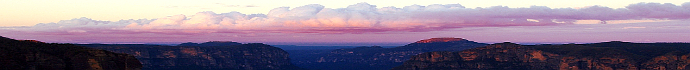
Winter 2012
October 12, 2012:
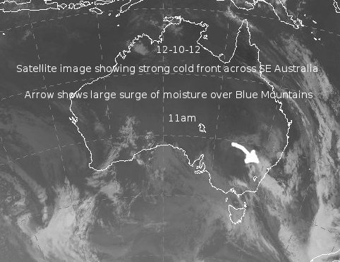
What an event this turned out to be. One of the best falls in the last twenty years, or longer, especially for mid October. Most of the models were showing a significant cold front more than a week before this system was due to arrive. Usually when there is model agreement to this extent, something is about to happen. Only as event day drew nearer did we get a clearer idea of the details.
East Coast Low pressure systems and surface troughs are well known for delivering moderate to heavy rain across the eastern seaboard. Their history is well documented. For once a system pretty much produced all of the ingredients needed for a good fall of snow across the Blue Mountains; a cold airmass, instabilty and that often missing ingredient, ample moisture. We have had similar systems before, namely in June 2007 and of course May 2000 and a few other decent ones in the last fifteen years but this October 2012 system really produced.
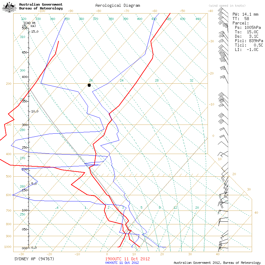
I was away on holidays during the build up to this event so my awareness of the finer details was not really up to scratch. All I had was a few trips into Coonabarabran, to get mobile coverage and briefly view the charts. The Sydney Weather Balloon Sounding on the afternoon of the 12th shows 500hPa temps of around -29.5C, 700hPa temps of about -9C and 850hPa temps of -1C. That is a cold airmass for October and for any month in winter and it was probably colder than that early on the 12th over the Blue Mountains and Oberon Plateau. Also, because of the presence of good instability and moisture, the 850hPa temps (situated at only a few hundred metres above Blackheath) would likely drop to -2C or colder during the best snow shower activity.
My wife and I made a decision to leave the Warrumbungles on Thursday morning the 11th, a day early, as we didn't want to be stuck on the GWH many miles from home during a snowfall, with two dogs in the back seat. I was thinking that it was possible we could get 6cm and maybe 8cm plus, if we were lucky but the most likely outcome was a cm or two.
By midday on Friday the 12th, we had a temperature still at zero and about 15cm or more of snow on the ground with large tree branches (and trees) snapping under the weight of the wet snow. For Blackheath some ninety calls were made to the SES for assistance and around forty for Katoomba. By 2pm the temp had risen to 2.8C and some light sleet and rain was falling. Katoomba also had a similar amount of snow, Bell even more, and of course the Oberon Plateau did well too. Little Hartley at 800M ASL also had settled snow to a cm or two. Porters Retreat, just south of Oberon, had around 20cm and Crookwell also had snow in the 15+cm range. Snow fell in many areas along the ranges including Guyra on the nothern tablelands and Taralga and Crookwell on the southern tablelands, just north of Goulburn. The Federal Highway also had snow across the road. More will be added to this report as time permits.
September 13, 2012:
Just a moderate little front that was cold enough in the middle and upper levels to produce some light snow. Porters Retreat, south of Oberon had nice snow showers at around 8pm on Thursday the 13th of September with a settling of around 1cm. I'd imagine there would have been similar snow showers around the Shooters Hill area and Mt Trickett as well, going by the radar last night. Blackheath had a nice freeze on Friday morning from the 2mm of rain on Thursday night, with nice ice puddles around. Saturday morning presented Blackheath with a melting cover but it was still 6 to 8cm deep. Even on Monday morning, there were small patches of snow left. Will add more to this report if its needed.
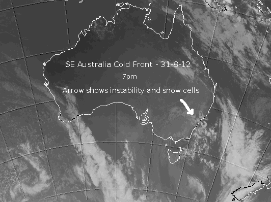
August 31, 2012:
This cold front was a little challenging to forecast. It was certainly not a classis system with broad instability and ample moisture but it improved just enough on the charts to keep snow forecasters interested. Surface pressure was quite high and this has the effect of stabilising the air mass quickly, causing it to 'ridge out'. The one thing going for this system though was that the air mass was quite cold with the Wagga Wagga weather balloon sounding on Friday morning (31/8) showing -29C at 500hPa, -11C at 700hPa and close to -4C at 850hPa. Those temperatures throughout the layers of the atmosphere can produce good instability and fairly low level snow (although not a lot of it in this case) and this is what happened during Friday afternoon and evening.
Goulburn, at around 700M above sea level had lovely snow showers at around 5pm, for half an hour on the Friday the 31/8. Blackheath had small hail and sleet showers commence around 4pm and this soon turned to snow at just before 5pm that fell continuously for close to an hour although the temperature was well above zero at this time so no settling occured. The wet snow was able to fall in temps of around 4C initially (dropping to 1.4C at 6pm) as the relative humidity was not too high (evaporative cooling effect on melting flakes) as well as the mid and lower levels of the atmosphere were notably cold. From about 6:30pm to 7:30pm there was another lovely burst of snow showers that fell in temperatures much closer to zero and some settling to about 0.5cm occured.
Saturday morning on the 1-9-12, produced a lovely overnight freeze under clear, calm skies. The minimum in my screen was -3C, our coldest morning all winter on the first day of spring.
August 17 and 18, 2012:
This system was always looking better on paper than the August 9 system as it had much broader instability, with lower mean sea level pressure. This tends to mean more snow showers across a larger area as cold air cells are able to develop more freely in the favourable atmospheric conditions. Of course, this doesn't mean every place on the map will see great snow and Blackheath certainly missed out on the best snow this time. The weather balloon sounding for Sydney this morning showed -30C at 500hPa, -10C at 700hPa and about -1C at 850hPa - a cold system although not quite as cold in the lower levels in a broad sense, as we would have liked.
Shooters Hill saw the leading edge of the frontal band arrive on Friday the 17th with hail commencing at around 11am and then sago snow and snow pellets soon after. It was snowing well and truly by 11:40am. By the time I left at around 1pm, there was 4cm to 5cm on the ground. Blackheath saw hail commence at around 12:17pm for fifteen to twenty minutes with a temp of around 5C and then at 1pm there was a greater intensity of hail when it was 'Teeming Down' according to the reliable observations from my wife. The temperature eventually got to around 1.9C at Mt Boyce AWS although none of this precipitation showed up in the gauge there, not unusual.
Overnight Friday in Blackheath the snow continued to fall intermittantly from about 8:30pm and until about 9am on Saturday. At times it was quite intense but with the temperature being above zero for all of this time, not a lot of settling occured. Apparently before midnight on Friday there was about 2cm outside the pub. Its clear by the Mt Boyce AWS that snow was falling during the night on Friday and into early Saturday but it didn't settle for long. Sunny Corner had around 8cm on Saturday morning and it seems Shooters Hill had at least 10cm, possibly closer to 15cm.
I may add to this report as time permits.
August 9, 2012:
Blackheath saw snow commence around 8pm on the night of the 9th (Thursday) and it continued for more than half an hour. My area in the south of town got about two to three cm but I'd imagine Mt Boyce may have gotten more as instability looked a touch stronger there on the radar - see link above. Next morning on the 10th saw a lovely freeze and a minimum of around -2C. So, we had frozen, crusty snow and lots of frozen water as well on places like the local netball courts.
This system was looking strong in the mid and upper levels with potent temperatures there to provide good snow making potential. The Sydney weather balloon sounding from Friday morning showed -29C at 500hPa, -10C at 700hPa and about -2C at 850hPa, it may have been a bit colder than that too, over the Blue Mountains the night before. From about a week before the event, there was discussion about its progress on the Weatherzone forums. Our main concern was the lack of strong or broad instability at the surface via low MSLP. Its typically nice to have MSLP at around 1005 hPa or even 1010hPa is okay, to produce the uplift/convection needed for widespread snow across the Central Tablelands.
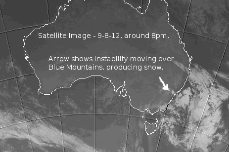
The models were showing MSLP to be around 1014hPa with this system which isn't that great. The most likely outcome when MSLP is that high across the CT is isolated snow showers/cold air convection and also a fairly quick fading/weakening of these cells as the higher pressure suppresses cold air, cell development/growth. This is pretty much what happened too, most areas up here didn't see much snow but Blackheath was lucky as an isolated pocket of instability moved right over us, as you can see via the satellite and radar graphics above. So why did we get such a nice snowfall if the pressure was so high? That's the thing with model forecasting, with their limited resolution they show relatively broad weather patterns and cannot really pick up isolated areas of better instability in a vigorous cold air stream. Invariably, there will be localised variations from the model predictions and good forecasters with local knowledge recognise this and factor in this potential during weather events. I'm certainly not suggesting I'm one of those good forecasters but I have made enough forecasting mistakes over the years to learn a little.
Areas like the Oberon Plateau and Sunny Corner also got snow although it seems it was no more than what Blackheath experienced. The coldest, most unstable air seemed to be confined to the eastern ranges.
In this day and age it was a fun little system. Nothing like the snow Blackheath used to get two or three decades ago but hey, we'll take anything these days and hopefully see some more this winter. I may add more to this report as time permits.
July 27, 2012:
Barely worthy of a report but it did snow briefly at Shooters Hill on the afternoon of the 27th. Some settling occured but the snow showers didn't persist for long. Earlier in the afternoon there was some sago and wet snow at Gingkin as well. Sunny Corner had a few sleet and snow showers too but nothing of real note.
July 1, 2012:
Plenty of fun for snow chasers on the Oberon Plateau today (Sunday July 1) although the amount of snow was generally light and mostly above 1200M - in the 3cm to 4cm range. Snow did fall down to about 1000M and the township of Oberon had a cm or two of wet snow on Sunday night but even in the town it was patchy, with the best snow settling under stronger cold air cells. Blackheath had snow at around 5:30pm on the Sunday and it settled to near 1cm on the ground. There was also snow pellets and sago snow at around 11am on Sunday in Blackheath that fell off and on for about fifteen minutes or so. The Sydney morning sounding for the 2-7-12, shows 500hPa temps of -28C, 700hPa temps of -9C and 850hPa temps of -1C. With the pressure quite high though, those 850hPa heights are pretty high now. The Wagga sounding from yesterday morning (1-7-12) was somewhat impressive with -31C at 500hPa, -11C at 700hPa and about -2C at 850hPa and some of this better instability is what allowed some snow to reach the Blue Mountains late on Sunday afternoon. It dipped briefly to 0.6C during the snow in Blackheath, so the snow didn't remain on the ground for long on Sunday night. At midday on the 1st, it was 4.7C in Blackheath and our maximum seems to have been 6C at around 2pm.
June 22, 2012:
This system was never showing up as a strong system for this far north but there was potential for handy snow in higher areas across the Oberon Plateau. The Sydney sounding for this morning shows approximate temps at 500hPa as -27.5C, 700hPa as -8C and 850hPa as -1C. The Wagga sounding was closer to -29.5C at 500hPa, -8C at 700hPa and -1C at 850hPa, so it weakened a bit as it moved to our area. That's still a pretty good airmass for winter, up this way, not amazing but good enough for snow. There was about 2 to 3cm of snow at Sunny Corner on the evening of the 22nd and snow showers in Lithgow but no settling. Amazingly, sleet and some wet snow was apparently observed at Mudgee, which is quite impressive with its low altitude. There must have been a strong, cold air convective cell there, a bit like the one that dropped the temp at Orange from 6C to around 1C on the evening of the 22nd.
Blackheath saw sleet showers on the 22nd at around 7pm, with some definite soggy flakes but no real snow. The temperature at midday on the 22nd was 4.9C, dropping to 0.6C at 5:30am on the 23rd. Wind chill varied from -2C at 9am on the 22nd and as low as -7C over the following 24 hours, not getting above zero in this time. There doesn't appear to have been a freeze overnight, into Saturday, so not much snow would still be around although high on the Oberon Plateau should still have some snow.
The trend of no snow settling below 1000 metres continues in the Blue Mountains. It is now right on seven years since Wentworth Falls has seen settled snow, that is the longest stretch in the forty years that I have been observing snow up here and it seems it could well be the longest recorded, snowless stretch, in over a hundred years, from the records that we have. More information will be added to this report as time permits.
June 5, 2012:
This system wasn't a classical south westerly system by any means but it was unstable enough and cold enough in the lower levels to produce some snow in the Blue Mountains and also across the Oberon Plateau. With a powerful low pressure system forming in the Tasman, near Sydney, there was plenty of moisture and instability in close proximity to the Blue Mountains. So, whilst this system was not overly cold (5-6-12 Williamtown 3pm weather balloon sounding shows - 500hPa temp = -23C, 700hPa = -5C, 850hPa = 0C) there was plenty of turbulent mixing of the mid level temperatures down to the altitude of the Blue Mountains. This turbulent mixing allowed the barely cold enough airmass to be a bit colder at our altitude than usual, especially directly beneath stronger convective cells. Blackheath had some of these colder air cells from around 8am to 9am on Tuesday the 5th, that produced sleet and snow.
The snow that fell was generally slushy snow because of those relatively mild upper and mid level temps but in the morning a few cm fell at Mt Trickett (above Jenolan Caves at 1360M) and Gingkin and snow showers also occured in Blackheath and places like Lithgow and Sunny Corner. At midday on the 5th in Blackheath, it was still only 1.8C. Blackheath saw snowfalls on the 5th, roughly from 7:50am to 8:50am but no settling occured as the temperature bottomed out at around 1.6C. There was another surge of moisture and convection in the afternoon around 3pm which saw sleet in Blackheath with the temp dropping to 2C for a short time and some snowy precipitation was observed. With their higher altitude, places like Mt Trickett and Sunny Corner also had more snow at this time, perhaps a few more cm. Winds have been fresh but certainly nothing like the winds we had on the 25th of May. Down on the coast however, Wattamolla, south of Sydney in the Royal National Park had sustained gusts yesterday afternoon of well over 100kph, peaking at 126kph and it is still peaking at near 100kph this morning on the 6th. More information for this report as time permits.
May 25 and 26, 2012:
This system didn't deliver much snow for the Central Tablelands (Gingkin reported a light settling and snow showers on the 26th) but it certainly delivered a lot of wind, peaking at 109km/r at Mt Boyce AWS on Friday night, the 25th. Apparently, the SES had 77 call outs from Leura to Mt Victoria during this event. Some fairly big trees came down in Blackheath, some on buildings but certainly not to the extent of our 139km/r gusts last year. Still, I think we could have seen winds around 120km/r locally on the 25th, especially on the western side of town.
By lunch time on the 25th the wind gusts were peaking over 50km/r and by 6:30pm it was closer to 80km/r but compared to later in the evening, those speeds were only moderate. Blackheath's position on a ridge increases our vulnerability to strong winds and this became more pronounced as the evening went on with sustained wind speed a problem as well, not just the gusts. From about 8pm on the 25th to around 1am on the 26th, we had a number of very strong gusts over 100km/r. This is when I heard trees cracking and falling, one of them a quite large pine onto a local Catholic church building.
The frontal system that approached on Friday comprised of the initial pre-frontal trough that delivered 17.6mm to the Mt Boyce AWS by 9am on Friday the 25th, a very welcome addition to our monthly rain total, that was virtually non existent until that time. The associated cold pool behind the frontal band was what interested snow lovers and unfortunately it wasn't that strong by the time it reached the Central Tablelands. Fragmentation of the cold pool had taken place and the upper temps and general instability were less pronounced, as this cold pool had been travelling over land all the way from South Australia.
So, plenty of cold and wind for the upper Blue Mountains but only a little snow for the highest areas on the Oberon Plateau. More information will be added to this report as time permits, be sure to check the photos link above.