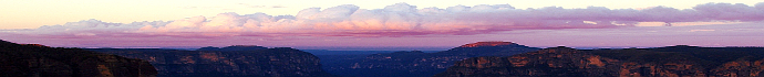
Winter 2014
October 14, 2014:
More Weather Charts for the technically minded - 14-10-14
NB:There has been some talk about why the snow did so much tree damage this time and why the european trees struggled to cope with the snow, when they should be used to it. Some preliminary thoughts: Firstly, the european trees in our area are not used to snowfalls of any kind as snow of note is much less common these days. Also, this snowfall was perhaps the wettest (heavy and sticky) fall I have ever seen here - it was like glue. It really wasn't cold enough through most of the layers of the atmosphere to produce a snowfall but thanks to that cold, very lower level cold pool over Blackheath/Lithgow etc, we just got this snowfall before it melted into sleet or rain - like it did in Katoomba.
Also, the european trees in this area were in full leaf (pretty much) so the snow had a lot to settle on. Add to that, the type of snow we had from this event would rarely be seen in any parts of europe as their snow is typically drier and less sticky. Blue Mountains snow is well known for being very wet and sticky as its partially melted snow by the time it reaches the ground, due to our very marginal conditions for snow in this area, ie: its barely cold enough here for snow. Still, rest assured, when very wet/sticky snow like this does occasionally fall on trees in parts of europe, it would also do serious tree damage.
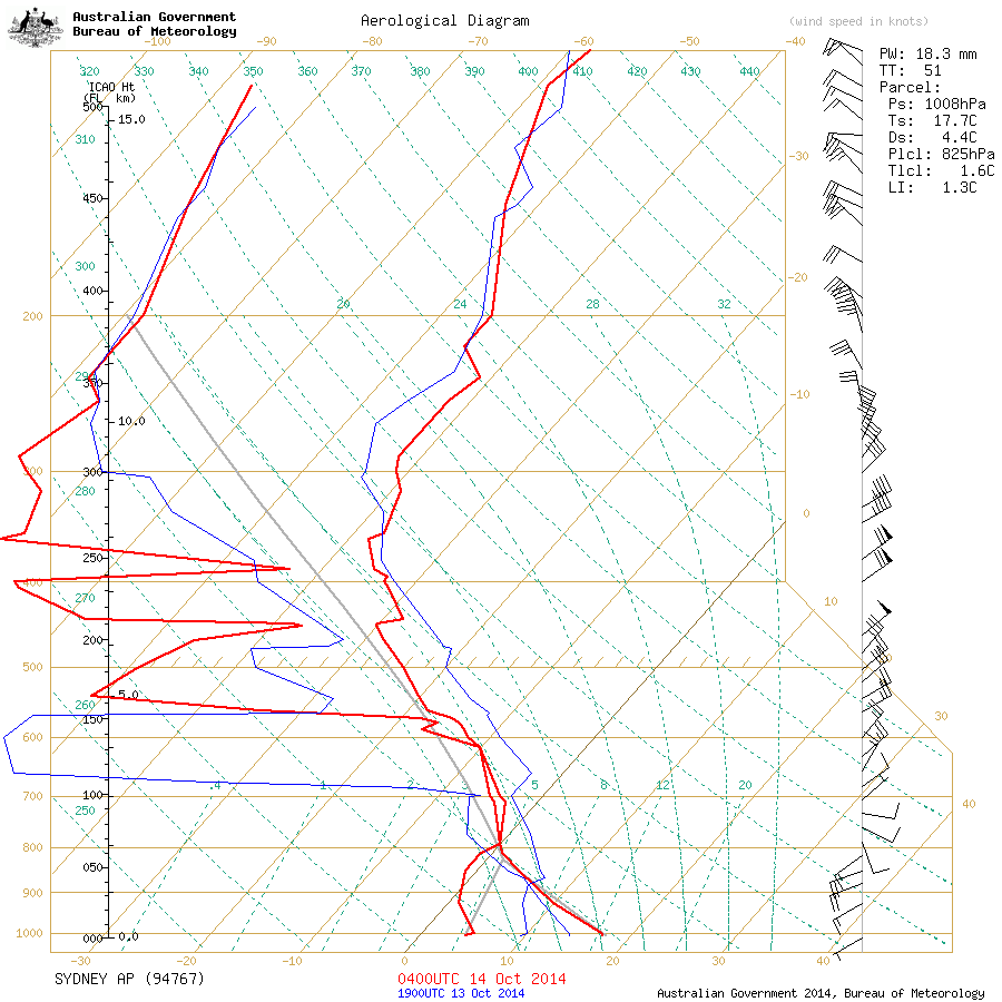
What a surprise little system this was. Although, from the weather balloon sounding on Tuesday, you wouldn't have guessed it. The surprise lay in the detail of this weather system.
A week out from the event, most charts indicated some sort of coastal trough/low developing with good rain and an associated upper low/trough in the vicinity that could maybe provide enough cold air for sleet or snow. There certainly seemed a chance of some snow up high on the Oberon Plateau but it didn't appear to be a high chance of more than a few snow showers or perhaps a settling of a few cm at best. I didn't think there would be more than sleet in the upper Blue Mountains, above 1050M, due to the lack of cold in the lower and mid levels on the charts, although there was an outside chance of snow, due to the nuances/interactions of upper lows with surface troughs/east coast low type setups. It turns out there was a quite cold lower level low that allowed the precipitation to survive as snow across the upper Blue Mountains, even though the mid and upper levels suggested rain at our altitude. The usual indicators on the charts at the 850hPa, 700hPa and 500hPa pressure levels didn't show this low level low.
Andrew Miskelly, a pilot and developer at Weatherzone and long time weather enthusiast, has produced some very good thoughts on this system over at liway forums, www.weather.liway.com. I thought I might post some of his thoughts here. All images and contributions below are copyright to Andrew, you can find Andrew Miskelly on Twitter, @andrewmiskelly.
Here are some of Andrew's thoughts
'...The commonality between the events that have produced spectacular dumps somewhere is that there's a cold lower layer being advected from the SW which is undercutting a SE'ly that has developed in the mid levels, the latter conveying very high moisture. I haven't figured out the mechanics at all, but Snowmi's later point about GFS not really resolving the situation (and indeed, it hasn't, missing the low temperatures at 900hPa and thereabouts) perhaps shows that we're only just now getting models that can resolve the situation. It seems quite impressive on the part of ACCESS. I think that mixing is not really a player, and that latent heat absorption (melting effect) is only an assisting phenomenon.
You always have to think of the atmosphere in three dimensions, and avoid the temptation of thinking that the story on an MSLP chart can be translated higher into the atmosphere. The charts we look at for pressure levels (e.g. 850hPa) are very similar to the familiar MSLP charts except that we're looking at the height (e.g. 1500m) of a given pressure (850hPa) rather than the pressure (1013hPa) at a given height (MSL). They can essentially be read the same though, in terms of establishing position of high/low centres, tighter isohypses (height contours on a pressure surface) - in turn related to high temperature/density contrast - being associated with stronger winds etc. But even then each of those charts is only a slice so when we talk about a 900hPa low or cold pool we're really talking about the position of the low (which has vertical extent) at the 900hPa pressure surface, or a cold pool in the layers surrounding 900hPa.
All of that is to attempt to describe how you can have the westerlies at one layer and the southerlies at another. Let's say we have an imaginary elevator at Sunny Corner and we start at sea level and stop to sample the view at barometric pressures of 900hPa and 700hPa (measured as we ascend through the atmosphere). At sea level we see the low is to our SE so we have westerlies. When the doors open at 900hPa we see that it's at much the same position (and the severe mesoscale surface lows that struck Sydney on Tuesday night are still evident at this level), indicating that it's vertically stacked in the lower levels. When the doors open at 700hPa though the low is more to our NE (because it's tilting a bit like the tornado on the previous page) and thus we have south easterlies (the winds essentially follow the isohypses up here as there's no surface friction). We also note that the air is thick with cloud and rain (snow) at this level because the SE'ly is advecting all the moisture in. Let's duck back down to 900hPa and take another look. Wow, it's cold for this elevation. Why is it so? Looking at an animation of the 900hPa chart for the entire model run it simply seems to be the case that a low level cold pool existed all day, starting on the SW slopes and moving in towards the developing east coast low during the afternoon, and receiving a little enhancement as it was forced over the central ranges. I will post charts tomorrow.
...So I think the sequence of events was (and generally is)
* Strong, sharp upper trough enters SW Vic and subsequently W NSW from the Southern Ocean bringing a conventional cold air mass at all levels.
* We know the low levels were quite cold if for no other reason than that Mt Macedon (870M ASL) had a bleak day on Monday.
* S/W NSW ends up with one of those widespread blobs of low-level cold air floating around looking for somewhere to go. Snowmi observed one of these out Broken Hill way a few weeks ago.
* Meanwhile, a cutoff upper low detaches from the Southern Ocean upper trough and drifts E across NSW - typically in the direction of the Hunter -> northern ranges.
* In response to this a surface low begins to develop in the Tasman (dependant on conducive conditions) and pulls west to north west towards the coast, essentially pulling into the upper low.
* The upper low goes offshore around the Hunter, spreading moisture laden SE upper level winds into its SW quadrant.
* Meanwhile the surface low in the Tasman is drawing very close to the coast around Sydney, bringing damaging S winds in its SE/E quadrant with westerlies persisting on its NW quadrant.
* All the while, the increasingly organised low (through the levels) has been organising and advecting the lower cold air sitting west of the ranges across the central ranges and into the low.
* The upper level SE winds and lower level cold pool being advected from the SW intersect over the un/lucky area resulting in heavy precip falling out of relatively mild middle levels (a little below freeing) into relatively cold lower levels (near freezing).
The un/lucky area varies from as far south as Bungendore etc. all the way north to the northern ranges (Pasha Bulker low, June 2007) but is commonly at the latitudes of the CT or northern ST (including the SH) it simply depends on the position of the low at the various levels which is affected by all sorts of things including SSTs and terrain at lower levels.
In the case of Tuesday, it panned out as below. Each of these charts shows RH and wind at 500hPa (chosen over 700hPa as the low [spinning bit] is 'simpler' and it emphasises really deep mid-level moisture) plus temperature contours for 900hPa to track our low level cold pool. Think of it as showing different aspects from both stops on our elevator ride. The red arrow tracks the 900hPa cold air. Note that there was further cold air at 900hPa and further up through the levels further NW and this provided the NTs' lighter snowfalls.
These images linked below are copyrighted to Andrew Miskelly
September 2, 2014:
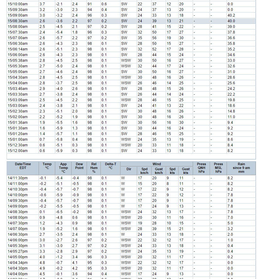
This frontal system was looking fairly cold for September by modern standards and most models showed an east coast low developing on Tuesday the 2nd, in the Tasman Sea. The Sydney weather balloon info on Tuesday afternoon showed the temperature at 500hPa as -27C, at 700hPa as -7C and about 1C at 850hPa. That's a fairly cold air mass for spring and this was indicated by the light snowfalls that fell across the Central Tablelands on Tuesday night. Blackheath had sleet occuring by 9pm and by 10pm it was snowing nicely. The temperature never really got below 1C so the snow didn't settle very much at all in our town. Gingkin on the Oberon Platea had a cm or two of settled snow by Wednesday morning and places like Yetholme and Sunny Corner also had snow showers on Tuesday night with some light settling by Wednesday morning. Even Guyra on the Northern Tablelands had about 1cm of settled snow on Wednesday morning. Mt Boyce AWS recorded 4.4mm of precipitation to 9am on the 3-9-14, most of that fell from about 9pm to midnight on Tuesday the 2nd. Apparently snow fell really nicely from about 11pm to midnight, although I was in bed by that time. The Mt Boyce AWS shows that the accumulation went from 3.8mm to 4.2mm during this time when it was around 1C, so it may have even briefly settled.
August 12th, 2014:
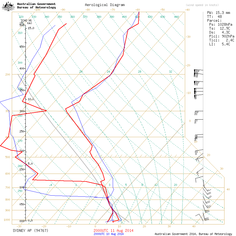
This system was always looking quite stable with high surface pressure of around 1028hPa on Monday night and into Tuesday morning with possible southerly or south easterly winds prevailing. This tends to cause showers to focus mainly on the coast, then they weaken quite quickly as they move inland. It turned out a little more interesting than that. The mid level temperatures at 700hPa, according to the Sydney sounding on Tuesday morning, were around -10C and lower down at 850hPa, it was around -2C. That is quite cold, even though it was only around -25C at 500hPa in the upper atmosphere. The atmosphere also had high relative humidity from 900hPa to 700hPa on the sounding, with SE winds pretty much from the surface to 700hPa and reaching 25 knots at the altitude of the Blue Mountains. So, even though surface pressure was high, there was opportunity for some nice, albeit brief, snow clouds to form, before they weakened across the ranges. Also, prior to the showers moving in around midnight on Monday, the surface temperature had dropped to around zero in Blackheath, cooling under the calm, clear skies at the time. This helped the snow to settle very lightly.
At 6:30am on Tuesday the 12th, there was light snow on my deck in Blackheath, only small patches in the yard - it was a very light settling. It also snowed lightly in Blackheath at about 1am and in Katoomba before midnight, from the reports I have recieved. Then at about 7:40am it snowed nicely in Blackheath for about ten minutes with some sleet at 8am and snow again at around 8:20am through to about 8:40am, occasionally turning to sleet. There was also nice snow showers at Bell at around this time.
August 1st, 2014:
This cold front was looking very cold for the southern states and quite extensive in its reach through NSW too. The concern from the outset this far north was moisture availability and this turned out to be the case in real-time. Pressure at the surface was fairly high (about 1012hPa and above) as this system moved across the Blue Mountains and it appears the very cold upper temperatures at 500hPa were also only just reaching our area, to produce good instability. The Wagga Wagga weather balloon sounding on Friday morning the 1st of August was -31C at 500hPa, -13C at 70hPa and -4C at 850hPa. That is a very cold air mass. It wasn't quite that cold as it slid NE across the Central Tablelands and moisture was certainly not that significant although some nice convective showers passed over the Blue Mountains on Friday evening.
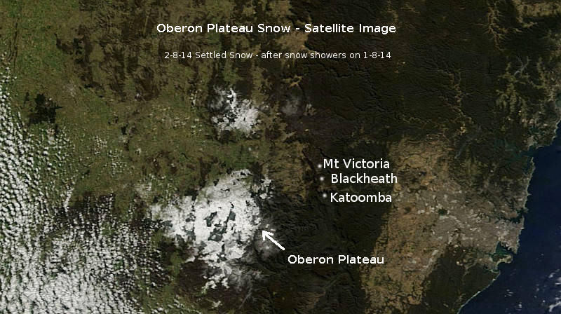
Blackheath saw a number of nice snow showers on Friday, from around 7pm to 9pm, that brought a light settling to about 1cm or so, this amount varied a little in town, which is typical of any shower activity. In marginal (not much moisture) snow conditions like Friday night, the south west edge of town tends to get more than say, at Govetts Leap, where showers from the W or SW tend to weaken and fragment. The Oberon Plateau had nice snow showers by Friday afternoon and into the evening although the limited moisture availability also affected that area with a few cm being the typical amount of settled snow, with some areas getting a little more.
July 17th and 18th, 2014:
This system looked particularly strong about a week before its arrival. We had cold temperatures forecast for the lower, mid and upper levels of the atmosphere - notably colder than most systems in recent years. This had us feeling very hopeful. Moisture initially looked good with quite solid indicators at 700hPa and high tot tots from most of the models. Sadly, by early Friday moring it was clear the best mid level moisture was staying just a touch south of the Oberon Plateau and Blue Mountains.
The Sydney sounding for Friday morning showed -30C at 500hPa, -11C at 700hPa and I'd estimate it was about -2C at 850hPa across the Oberon Plateau during the snow at around 1am to 6am. The highest areas of the Oberon Plateau above 1250M appeared to have about 5cm to 10cm of settling with lighter falls in areas like Orange and Blackheath of about 1cm or so. Thursday night also saw light snowfalls on the Oberon Plateau and Blackheath saw sleet just before dark on Thursday. The frustrating phenomenon of cold fronts fragmenting as they head NE from the ski fields continues - there's often one or more components of a good snowfall missing. Its been a part of the changing climate since about 1990 up this way. I will add more to this report as time permits.
July 9th and 10th, 2014:
This system was looking quite good on the charts, even stronger than the June 28 system via some models. One of the concerns was that there was some model disagreement on just how strong this front might be. This model uncertainty continued until not long before the event, which tends to make me a little curious. That is, there may be some variables at play that could produce some incertainty in outcomes. By Wednesday afternoon and evening there was light snow falling on the Oberon Plateau, especially above 1200M and places like Sunny Corner had light snow showers. By Thursday morning there were light snow showers again on the Oberon Platea but not very much. Accumulations out there were only a few cm at most, in some of the protected areas. Blackheath had some sleet showers on Thursday morning before 8:30am but you certainly couldn't call it a snowfall.
So what happened? The BoM forecast on Tuesday night even said a chance of snow showers for Katoomba, so why such a benign event over this way? The ACCESSR model analysis for 00z, 10th of July, shows that the very good upper cold air and instability (-11C at 700hPa, -30C at 500hPa) was centred over a line from Dubbo to Coonamble at 10am. It then headed to the northern tablelands by 1pm. Across the Oberon Plateau and the Blue Mountains, the mid and upper level air mass was not as cold, with the Sydney afternoon weather balloon info showing -27C at 500hPa and -7C at 700hPa. So, in a nutshell, the coldest, most instable air that would produce the best snow stayed west and north west of us and brought light snow to places like Walcha on the northern tablelands and Hanging Rock, approximately 50kms SE of Tamworth. The air mass had dried out quite a bit by that time and only produced light falls.
Be sure to check the snow photos link above for a snow video of the event on the Oberon Plateau.
June 28, 29 and 30, 2014:
This system was also showing up pretty early on the charts and it looked quite good in all areas; moisture, cold through the layers of the atmosphere and instability. A SW system is always going to favour the Oberon Plateau and areas like Sunny Corner etc (The Oberon Plateau acts as a snow/rain shadow to the Blue Mountains) and this is what it did. Sadly, the amount of moisture predicted didn't quite live up to expectations so snow on the ground was relatively light. Blackheath had snow showers on Saturday afternoon that were lovely but mostly light, whilst places like Oberon and higher up on the Oberon Plateau had a light settling. More light snow fell on Sunday in Blackeath (for five to ten minutes minutes at around 8am) and also on the OP and then again on Monday at Shooters Hill and Sunny Corner etc, where an event total of a few cm (possibly up to 6cm) occured and Sunny Corner had a similar amount, perhaps a bit less.
The Sydney weather balloon sounding for Monday morning, the 30th of June, showed a nice cold atmosphere with 850hPa temperatures around -1C, 700hPa temperatures around -9C and 500hPa temperatures around -29C. Total totals index - a measurement of instability ( where TT = Td850 + T850 - 2(T500) or (Td850 - T500) + (T850 - T500) - was quite high over the Central Tablelands too at around 55.
So why did we not get better snowfalls and a settling in the Blue Mountains on Monday, when our chances were quite good? The Total Totals Index that I use is a commonly used method of determining moisture/instability in the atmosphere (especially for thunderstorms) but its not perfect. Laurier Williams from Australian Weather News reminded those of us from the Liway Forums that Total Totals Index does not take into account the moisture levels at 700hPa. This is where we need good moisture for snow on the Blue Mountains when a system is coming from the SW. Apparently the K Index, something I haven't used, is a useful means of adding 700hPa moisture into the instability predictions, that may work well during winter cold fronts.
The Blue Mountains also needs an air mass to have quite cold lower, mid and upper levels for snow (to produce optimal instability, keeping snow clouds alive from the Oberon Plateau) which we did get but sadly, that critical component of moisture in the mid levels was missing. For the last decaded or two, this has been happening more often, one or two components of a good cold front are usually missing. Cold fronts seem to be fragmenting as they move NE, behond the ski fields. This is just my take (Thanks in part, to the great insights of Laurier Williams) on this cold front. Feel free to add corrections or more info via email, if you have more thoughts. I may add more to this report over time.
June 24, 2014:
The models were portraying this event about a week before it arrived. There was certainly some variation in the outcome initially but as we got to within three days of the event, the picture was becoming clearer. A quite strong front for the ski fields and a very windy front for the Central Tabelands with some snow. By day break on Tuesday the 24th, there was light snow occuring in Blackheath which continued off and on for an hour or two but never heavy enough to settle. Our temperature bottomed out at about 0.6C after the BoM predicted about 2C as a minimum. The models don't yet have a good enough resolution to resolve subtle variations in a very small elevated area like the Blue Mountains so things like snow and minimum and maximum temperatures can be a little off the mark during cold outbreaks.
Out west on the Oberon Plateau where it got to 0C or colder, there was perhaps a few cm of snow above 1250M and the Oberon township had a dusting/settling too. The Wagga weather balloon sounding indicated that the temperature at 850hPa was -2C, -9C at 700hPa and -24C at 500hPa. That's quite cold down low but the 500hPa temperature was not really cold enough for strong cold air convection. There also wasn't a lot of moisture associated with this system, this far north.
Winds in Blackheath on the 24th reached 95km/r, as of 3pm Tuesday but would have been 10 or more km/r stronger nearer to the escarpment edge in some places. At midday in Blackheath, it was 3.7C with a -7.6C wind chill.
May 3rd, 2014:
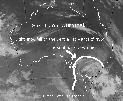
This cold front showed fairly good promise around a week before it arrived on the forecasting models. Initially there was a quite strong upper air pattern at 500hPa expected across the central tablelands but as time went on, the models showed the upper cold pool moving towards the northern tablelands. At the surface, a significant low pressure system was expected to develop off the coast of NSW. It was just a matter of where the best instability would form for any snow prospects. As the event approached, it was fairly clear that it was not going to be a super cold system and that snowfalls would likely be light with isolated heavier falls. As often is the case north of the ski fields these days, the upper temperatures at 500hPa fragmented as the system moved north, towards the central tablelands. This fragmenting of upper level lows and troughs may be related to climate change and the general weakening of the jet stream this far north. Surface systems often don't get the very cold infeed of air from higher in the atmosphere to sustain them.
I went out to Shooters Hill on Saturday morning where light snow was falling by 9am with a dusting on the ground. It continued to fall for the three hours that I was there but never really settled much. Sunny Corner (not far from Yetholme) had about 3cm of settling at this time. Anywhere below about 1200M had sleet although there were some isolated areas of snow at lower levels. Blackheath had a few flakes and sleet but it was very marginal over this way. The Sydney sounding for Saturday morning had the 500hPa temps at around -24C and about -6C at 700hPa and 2C at 850hPa. It would likely have been a bit colder than that at 10am at Shooters Hill, where surface temperature there was about 0C to 1C. Most of the snow that fell there, to my mind, was orographic snow, with small pea sized flakes. Occasionally, the flakes were bigger under stronger cold air cells.
In the end, the northern tablelands didn't actually see much snow although snow showers were observed there. At the upper reaches of Barrington Tops it appears they had a good fall of wet snow, with more than a few cm settling there. Mt Cannobolas near Orange had a good fall of snow on the summit that was estimated at 15cm. Lower slopes of Cannobolas also had settled snow but much less than the summit.
I will seek to add to this report as time permits. It was a marginal event really but still fun.