Winter 2015
August 12th, 2015:
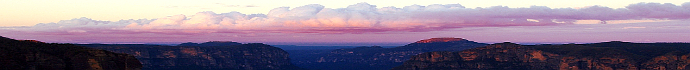
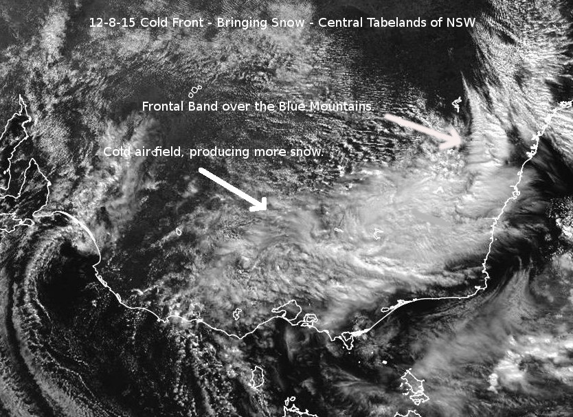
The Wednesday, August 12th system moved across the Blue Mountains during the mid morning. Dawn greeted us with a balmy temperature of around 5C, quickly rising to 10.1C by 9:30am in the gusty pre-frontal NW winds. By 11:30am, it had dropped to 1C in Blackheath with snow falling in the frontal band. The flakes were quite large indeed, up to 4cm across, which is often a sign of multiple flakes sticking together in the relatively mild low levels of the atmosphere. There was a light settling at this time but it never quite got cold enough for snow to notably settle in Blackheath, with the temperature always staying above zero and only briefly getting to 0.5C in the heavier showers in the cold air field, behind the frontal band.
Temperatures via the Wagga Wagga weather balloon info, showed that the atmosphere was fairly cold in the upper levels at 500hPa (-29C) and notably cold in the mid levels, being -10C at 700hPa. It was around -1C to -2C at 850hPa, so not seriously cold in the lower levels to produce sustained settled snow in most areas. The relative humidity was good from 850hPa to 500hPa, so in the unstable atmosphere good snow bearing clouds were able to develop. These were more concentrated across the Oberon Plateau and places like Sunny Corner and Orange as they are more exposed to the westerly winds although the Blue Mountains did quite well at times too, seeing lovely snow showers during the day.
Throughout the afternoon more snow showers occurred in Blackheath and across the Blue Mountains with flakes observed in Leura and Wentworth Falls. Lithgow also had snow showers and Orange had a light settling early in the day in the pre-frontal band and also throughout the day in the cold air field. Blackheath also had a settling at around 6pm but it never snowed for long enough for this settling to be significant. The Oberon Plateau had about 5cm of snow settled snow above 1300 metres at Shooters Hill and a few cm lower down. The township of Oberon had periodic light settling throughout the day.
It was a good system with decent instability and moisture although the lower levels of the atmosphere needed to be just a touch colder (a degree or two) and we would have seen a nice settling in the upper mountains. The high point for me was hearing the school children at our local primary school screaming with delight as the lovely (and at times heavy) snow showers fell during recess.
July 16th and 17th, 2015:
The July 16th/17th snowfall was one for the ages. Initially, most snow lovers were looking at the prospects of the 12th of July event and the next potential event on July 16th wasn't in our main focus. Our focus soon sharpened. The July 16th and 17th event was perhaps the most extensive snowfall across NSW since 1965 (to be confirmed) and possibly the heaviest settling in Blackheath since 1984. Here's some initial thoughts from Andrew Miskelly from another weather forum and then after that, some more report details.
You can contact Andrew via Twitter = @andrewmiskelly
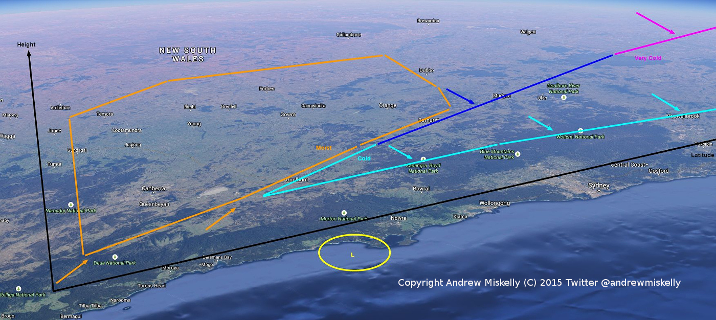
Click on the NSW Cold Air Profile link above, to follow Andrew's points below:
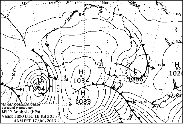
'It's all about the temporary interaction of two air masses.
* ...The cold air mass (blue) was edging N -> NE across NSW for a few days.
* It was associated with deep, cold air which came up from the Southern Ocean.
* As it moved across towards the Tasman Sea an offshore low (yellow) began to develop in the lower levels (off the Illawarra, at the surface).
* This assisted a moister, maritime air mass (orange) to be drawn in from the east and south east off the Tasman.
* So you have the cold air mass pushing eastwards across the central and northern parts of the state and a moist air mass coming in from the south east around a low which by Friday evening tilts from off the Illawarra at the surface to over the Hunter in the upper levels.
* During Friday, we observed that the cold air mass edged south ever so gradually in the lower levels during the day - itself being drawn into the developing surface low. We observed that a light ~ northerly wind shift heralded its arrival.
* The two air masses are thus on converging paths and as Friday afternoon wears on they begin to meet and the moist air mass pushing up from S/SE of Goulburn starts to ride over the incumbent dense, cold air. The latter is shallow in the south but it doesn't matter because as you go up in altitude it's below zero in the moist air anyway.
* Despite the SE change moving in through the mid levels, the cold air mass stubbornly creeps east and a little further south in the lowest levels, as the surface low continues to have its effect. You can see this in the wind directions on the Skew-T (for Goulburn) I posted. Being drawn over the ranges assists with a little further cooling.
* The coalescence gradually moves north to the extent that on the SE central ranges the continuing precipitation turns to rain before ceasing. At 5am here on Friday it was 0.5C and raining. That means that 100m, say, above the surface, the temperature was not getting any colder. Indeed the milder air was finally becoming dominant.'
The 500hPa analysis charts show us that the coldest, most potent part of the cold pool, was over the northern tablelands or thereabouts, at 10pm Thursday the 16th. It was -32C or colder there at 500hPa and 'only' in the -28C to -30C range across the Blue Mountains. So, how did we get so much snow? Read on.
From about Thursday the 16th at 10pm, snow fell right across the Blue Mountains (and indeed the central tablelands) to quite low levels. Winds at our altitude were from the SE and snow was fairly continuous until about 9am on the 17th, with intermittant falls after that until close to midday. There was a lower level cold pool at 900hPa and lower that kept the snow quite dry.
Megalong Valley and Kanimbla Valley appear to have had up to 7cm or more, in some areas, as low down as 600M, according to photos I have received. The upper mountains towns received quite heavy snow by their standards with Blackheath recording about 18cm to 19cm and Katoomba 17cm.
In many ways, things were setup just about perfectly for the July 16/17 event with very high surface pressure anomalies (ie: surface high pressure in the Bight was unusually high for this time of year) which isn't always good for the ski fields (can block cold fronts) but can also send very cold air towards the central tablelands at times.
Plus, the sea surface temperatures off the coast of NSW were also warmer than average near Sydney (helps low pressure systems intensify) plus a notable cold pool at 900hPa. This low level cold pool wouldn't be picked up by the usual snow forecasting method of using the 850hPa temperatures and theoretically decreasing the temperature adiabatically as you go down to the Blue Mountains altitude.
The cold pool at 900hPa was very cold, colder than the temperature at 850hPa, from what I have seen, so far. When you have an overlay of moisture from the maritime surface low (SE winds in this case, loaded with moisture) being feed into the cold, lower level air, bingo, lots of snow. This low level cold pool at 900hPa and below, was of particular interest to the low altitude towns in the central west that recieved very notable snowfalls. It helped keep the snow 'alive' as it fell across towns well below 700M in altitude.
As Andrew Miskelly has reminded us: 'One of the lessons (as with last October 2014) is that it doesn't matter if the coldest upper atmospheric temperatures are further north - if you have cold enough temperatures in the low levels and lots of precip coming over the top then what more do you need? As has been the case this time (see Guyra), it's usually the case that the cold-est temperatures are in fact where the dryer part of the air mass is.'
Another weather mate of mine, Michal, has helped me see this event more clearly, here is his take on this event:
'My thoughts on the snow event over NSW of 16-17/07/15. This event had a lot of similarity with a Northern Hemisphere snow event because it was created using a large land mass as stepping stone. In this case that stepping stone was inland NSW. A stalling and very slow moving cold pool moved into NSW from South of SW Victoria on the 15th.
The 300mb jet stream was feeding the cold pool from the SSE once its in NSW, keeping it alive and getting colder. On the 16th a large area of cold air was able to exist over NSW thanks to the slow moving nature of this system and cloud and cold feeding winds kept cooling the atmosphere.
Over that 24 hours while the cold conditions sat over NSW the lower layers of the atmosphere below 850mb were able to cool down largely removing the lapse rate below 850mb. At the same time the upper layers remained unstable with a normal lapse rate at temperatures conducive to produce snow.
The temperatures above 850mb over the CTs were good near -28 at 500mb -9 at 700mb but nothing super exceptional of a massive cold snap. Temps in the North of NSW were more exceptional. However because the atmosphere below 850 was chilled out almost to the surface snow was able to fall through to surfaces at low elevations.
This chilling was only possible because the airmass sat over land and was being fed cold air long enough. As the cold air gradually finally made a move over the East coast the classic SE surge of moisture was able to be fed to the cold air to produce a final burst of snow into early 17th.
Temperatures at 1200M were about -1.5, but as low as 600M was 0.0, only a lapse rate of 1.5deg/600m. This is very unlike some major cold changes like the May 2000 event where lapse rate remained normal and the front swept through NSW fast not stalling and keeping colder temps at 850mb but warmer at 900m. This event was colder at 900mb but warmer at 850mb.
Many Northern Hemisphere snow events over land masses behave like today where the air is chilled in the low layers below 850mb. You notice that in Europe as you move East and snow increases on the ground as you reach Czech Republic and finally Russia. In Europe there is also an interface of the chilled airmass of the East and the maritime airmass of the Atlantic countries that can produce heavy snow like the heavy snow on the CTs today.
In Europe this situation is more common but it takes quite a bit of luck for all this to line up in Australia. One factor that helped a lot was the high SAM value which kept frontal systems slugish and allowed this slow movement. But a brief localized stratospheric warming SW of Australia that started end of June allowed a cold surge to break through an unfavorable polar vortex long enough to cause cold air to escape to a region where it otherwise would not have gone.'
NB from Blackheath Weather Webmaster: Still learning about the details, its all very fascinating. I'm happy for Mets and experienced forecasters to add to/correct any of the details so far.
NB: I've heard some folk saying that the October 2012 event was a much heavier settled snow event, as it broke a lot of trees etc. This isn't the case. The July 17, 2015 event produced about 2cm or 3cm more snow on the ground than the 2012 event for Blackheath. The October 2012 event consisted of much wetter snow, it was very sticky and clung to trees until they collapsed.
July 12th and 13th, 2015:
I wasn't here for this event although some excellent video footage was taken during the light snowfalls that occured in Blackheath. See the photo link above and head to Mr Nasa's YouTube page and also OP Snow Chaser.
Blackheath had light thunder snow at around 10:30pm on Saturday the 12th and other short periods of snow in the late evening. By Sunday the 13th, there were Blackheath snow showers intermittantly throughout the day, sometimes quite heavy although very little settling occured. The Sydney weather balloon info shows that it was around -29C at 500hPa, -8C at 700hPa and -1C at 850hPa. As the winds were predominantly westerly, the light snow that fell, occured mostly on the Oberon Plateau, where a few cm accumulated.
June 5, 2015:
A fairly benign looking system passed over the central tablelands on the 5th of June. There was a low level cold pool near 900hPa that helped any precipitation survive as snow, even though the mid and upper levels were not that cold. Weather balloon readings from Sydney in the morning were -24C at 500hPa, -6C at 700hPa and -1C 850hPa. The Oberon Plateau up high got a few cm of snow, with places like Gingkin and Shooters Hill having a nice covering. The Oberon township had a light dusting as well. Blackheath had snow showers for a brief period just after 2am. Some good video and photos were taken. Please head to the photos link above. The Mr NASA and OpSnowChaser YouTube accounts there have good videos. More will be added to this report later, if its needed.
May 13, 2015:
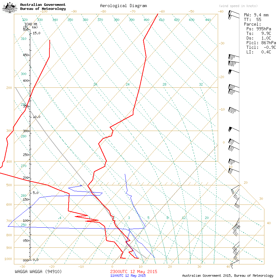
A few days out from this event it became quite clear that this system was going to produce a cold air mass (especially in the mid and upper levels) although the lack of a surface low nearby and the resultant high surface pressure, suggested snow would be light this far north. Typically, the higher the surface pressure is as the front passes over an area (in this case it was 1020hPa in our area and higher) the less chance there is for clouds to develop and precipitation to form. As the airmass moved over Wagga the weather balloon sent up from that area showed the temperature at 500hPa to be -32C, at 700hPa it was -13C and at 850hPa it was around -1C. That is a seriously chilly airmass!
There just wasn't enough uplift of the air at the surface in our region to produce nice snow bearing clouds, so even though a good cold air cell was moving our way from near Canberra, it gradually died as it reached here. All Blackheath saw was light snow flurries at around 8pm Wednesday evening. We had some hail earlier in the day and Shooters Hill on the Oberon Plateau also recorded light snow during the day. There was a light settling in the evening at places like Mt Trickett and Porters Retreat.
April 7, 2015:
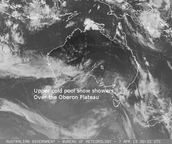
A nice little system passed over NSW on Tuesday the 7th of April. At 10am on Tuesday it was a very balmy 14.6C in Blackheath before dropping to 6.7C at 1pm and 4.8C at 3pm. Hail fell briefly in Blackheath just before 3pm and there was very light and brief sleet at around 6pm. Wind chill temperatures in Blackheath reached -4.2C at 2am, Wednesday the 8th and was mostly below zero from 3pm on the 7th until 10am on the 8th. Maximum wind gust was 76km/r at 6am on the 8th although there would have been notably higher gusts in town, in exposed areas.
Shooters Hill had nice snow showers on the afternoon of the 7th with some light settling. Numerous spots on the Oberon Plateau had sleet or snow above about 1200M. Quite a nice snowfall for April. An old mate of mine that has lived and worked in the area for over seventy years tells me that April snowfalls were not uncommon but they often went unreported as did many snowfalls in the old days as they were much more common. Still, this fall was quite impressive for this time of year although it didn't compare to the one in late April in 2008. More info may be added to this report as it comes to hand.