|
Home
Note: These are just some basic notes on ECL's to get you started. They are not definitive.
One of the most exciting weather events for cold weather lovers is the East Coast Low. These earnestly awaited, maritime gifts typically occur in autumn or winter with an average frequency of one or two per year. It seems that their yearly occurrence peaks every ten years or so (L.C Hopkins and G.J Holland) when up to six ECL's can develop in a given season. So why is this weather phenomenon so interesting to cold weather lovers? Its produced some great snow events over the years and we all sit around waiting patiently for the next one. Could it be this year?
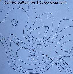
A typical precursor to ECL development is when a large pool of warm water breaks out of the tropical ocean and heads south, along the east Australian coast. Such an event may repeat itself over a course of weeks throughout the winter period. Added to this foundation, an upper level cold pool needs to move in over a surface trough that is situated north of a strong subtropical high pressure system. In the image immediately below, you can see the surface patterns developing to assist potential ECL development. The surface pressure trough marked with the "L" north of Sydney sits atop a subtropical high pressure ridge that is centred over Tasmania, marked "H" and extends over New Zealand.
Night-time development is preferred for East Coast Lows as the strong temperature gradients between the cold land (especially in mid winter) and the warm ocean eddy strengthens the system. Further intensification arises as warm ocean air is forced over the cold land air, releasing latent heat as cloud and rain forms. With the high ground of the tablelands just inland from the coast, the associated forcing can really enhance development of the low if easterly winds are directed onto the coast. Usually, if/when the ECL moves away from the coast, it weakens rapidly. Upper level support for ECL's can be in the form of the sub-tropical jet stream where the divergent, poleward exit region is of assistance. Some of the most severe forms of ECL's can produce winds in excess of 150kph and very heavy precipitation. Ah, now that's the word that gets snow lovers excited over the NSW Central and Northern Ranges. Precipitation. Something that can be missing during cold outbreaks from the usual direction.
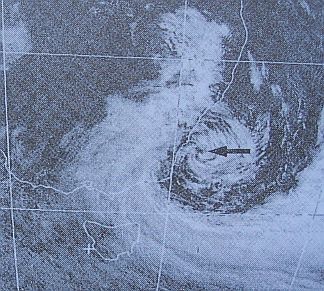
The images immediately below show an East Coast Low firing off the NSW coast. This ECL is a little too far south for my liking for good snow for the Central Ranges of NSW but you can see how cloud and rain and strong winds are being driven onto the coast south of Sydney. If this system was further north, say centred off Newcastle, the strong winds and rain south of the arrow in the image below would be driven onto the Central Ranges of NSW with maybe a great snowfall. Of course, the upper level cold pool that has helped develop the ECL needs to be cold enough along with good lower level, cold advection for snow to develop but under optimal conditions, you could expect snow along the NSW ranges to 900 metres or lower, depending where the centre of the low was situated. Remember, the "eye" of the low usually needs to be centred north of Sydney for the clockwise winds to then direct moisture over the coast adjacent to the Central Ranges and indeed the Blue Mountains. In the image below, you will note how the coastal strip is mostly cloud free north of say Wollongong, as the prevailing winds are westerly there. This has the effect of drying out the air on the leeward side of the ranges.
So, keep an eye out for easterly dips in the surface patterns and you never know, you might just be the first to spot an ECL bomb exploding off the coast...if you stay up late enough.
Further ECL descriptions and images
2001 Event - Andrew Miskelly has a good report of a great ECL event for Taralga and surrounds. Go there to get an idea of what these ECL's can produce!
1965 Event And also to the same site for this great snow event that was almost certainly an ECL for the Blue Mountains and Central Ranges of NSW.
Any further ECL links or photos, feel free to contact me for inclusion.
Home
|