Blue Mountains Weather Warnings on 1300 659 218
NB: If you want even more details, please contact The Weather Company for personalised weather forecasts on 190 222 9569. Be aware that this service is charged by the minute. I do occasionally provide personal forecasts for community groups via email.
Real-time Twitter Weather Updates: Apart from the detailed local weather observations below, you can also head to my Twitter live feed link. Click here.
5-1-13, Saturday 8am: December in the upper Blue Mountains was a little above average for both minimum and maximum temps, at 12.2C and 22.9C respectively, which for both min amd max is 0.7C above the long term average. Rainfall was 70.8mm for December which was well below the long term average of 123mm. Our hottest day was 30.9C (24th) and our coldest was 11.4C (10th). Even though it was cold and barely into double figures on Christmas Day at midday, it was milder in the morning, so the maximum for that day came in at 16.6C.
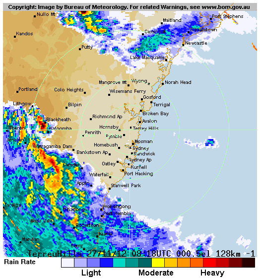
27-11-12, Tuesday 9pm: What an intense storm we just had tonight. From around 7:20pm to 8:10pm we had 55.1mm. Some very close lightning strikes as well plus some hail to 1cm but not a lot. A tight and intense little cell formed ahead of the main line of storms at around 7:10pm and ten minutes later it exploded over town. All up we had 60.6mm for the event to 9am Wednesday, the 28th. You can see a radar archive of the event here.
31-10-12, Wednesday Midday: October in Blackheath was close to the long term average with average min temps at 6.8C, which was -0.7C below the long term average. Max temps for October were 18.5C which is +1C above the long term average. Rainfall was 40.4mm for the month which is quite dry, compared to our average of 73.3mm.
September in Blackheath was milder than average with average min temps at 5.3C, which was right on the long term average. Max temps for September were 15.8C which is +1.4C above the long term average. Rainfall was 37.8mm for the month which is quite dry, compared to our average of 61.7mm.
August in Blackheath was cooler than average with average min temps at 2.1C, which was -1C less than the long term average. Max temps for August were 11C which is -0.3C below the long term average. Rainfall was only 11.2mm for the month which is very dry, compared to our average of 57.1mm.
3-8-12, Friday 8am: July summaries are now in. Using the long term records from Katoomba, July averages were 0.6C above average for minimums and 0.9C above average for maximums for the month and our rainfall was about half the average at 45.2mm (average = 83.8mm). These figures show the distinct lack of strong cold fronts in July with also no very cold days at all, our lowest maximum being 6.4C on July 5 although Mt Boyce had 5.9C on July 2 and 5 - I can only presume Mt Boyce was under cloud on July 2, to be so much cooler than Katoomba on that day. This is again unusual for the upper Blue Mountains, to not see at least a few days with maximums around the 2C to 4C mark.
We have also hardly had a minimum temp below zero this winter, only one at Katoomba and three at Mt Boyce - that were just below zero. That is also very unusual. I think August will show an improvement in frontal weather but just how good, remains to be seen. The climate is changing markedly up this way, so much milder in the last ten years. It makes living up here a bit easier in winter for sure but for the snow lovers amongst us, its a bit disconcerting. Rest assured, the ski fields (and even Tasmania) are seeing notably less snow as well, this year and generally for a number of years now.
28-7-12, Saturday 9am: June in the upper Blue Mountains via the longer term Katoomba station, showed 4.3C (+0.5C above long term average) for minimums and 10.1C for maximums (-0.3C below long term average) for the month. Katoomba June rainfall total was 170mm which is well above the long term average of 117mm. So, a wet month and also a pretty average month for temps with no strong cold fronts. The lack of strong cold fronts was indicated by the lack of any days with a maximum below 5C, which is unusual for the Blue Mountains, as we usually have at least a few really cold maximums in June.
11-6-12, Monday 9am: May in the upper Blue Mountains via the longer term Katoomba station, showed 5.4C (-0.8C) for minimums and 14.3C for maximums (+0.9C) for the month. The main reason for the minimums being lower than average was the lack of rain until late in the month. Katoomba May rainfall total was 21.6mm which is well below the long term average of 102.1mm. So far June has been around average with a little snow on the 5th but there is no prospect of strong fronts for the rest of the month at this stage. Stay tuned though as things can change quickly at this time of the year.
14-5-12, Monday 9am: April in the upper mountains was a touch above average for maximums and minimums. Mt Boyce recorded 9C for minimums and 17.6C for maximums, which was 0.3C and 0.4C above average, respectively. Rainfall for April was 105mm, the average being 61.7mm. Katoomba with the longer term records recorded 9.3C for minimums and 18.1C for maximums, which was 0.5C and 1.1C above average, respectively. Rainfall at the Katoomba station was 135.2mm for April, with the long term average being 121.3mm.
20-4-12, Friday 9am: 87mm from the Mt Boyce gauge for the rain event that effectively ended yesterday morning, apart from some light drizzle since. Not a bad drop, the showers were pretty heavy at times.
18-4-12, Wednesday 2pm: April observations for Mt Boyce AWS are currently running +1C above average for minimums and +2.4C for maximums. This isn't unusual in early autumn when periods of more stagnant weather patterns can persist, bringing either calm, warm weather or misty/damp days. Today has been very wet though, with 34.6mm to 9am and more than 10mm since then. It should cool down over coming weeks, as the models are showing cut-off weather patterns and potential cold pool development.
18-4-12, Wednesday 1pm: March observations for Mt Boyce show that it did turn out to be cooler than average for both minimums (10.5C) and maximums (19.1C) which was -0.9C and -1.5C below the average, respectively. Our March rainfall total of 268mm was well above the average of 100.9mm and a 16 year record as well. The Katoomba March average minimum came in at 10.9C and maximums at 19.4C, which was -0.6C and -0.9C below the long term average respectively. Katoomba rainfall was 276.2mm for March, well above their long term average of 163.76mm.
27-3-12, Tuesday 2pm: A nice presentation by the BoM on the State of the Climate. Its clear by their reckoning that the warming climate trend in Australia has not changed although the last two years have been somewhat cooler, see more here.
22-3-12, Thursday midday: February in the Blue Mountains was generally cool to mild and wet. Mt Boyce AWS produced 247mm for the month, the average is 122.3mm. Our wettest day was 35.4mm on the 20th. There were few days without rainfall (around 7) and almost no days at all with pure sunshine. Average maximum temps were 21C, which is -1.9C below the average. Average minimum temps were 12.4C, which is -1C below the average. Katoomba produced 270.8mm for the month with their average being 173.4mm. The average max and mins for the month at Katoomba were 21.2C (-1.2C below average) and 12.9C (equal to long term average) respectively. March for Mt Boyce is currently running close to average for minimums (11.1C) and about 1C below for maximums at 19.7C with rainfall at 254.6mm thus far.
13-2-12, Monday 2pm: Katoomba experienced a serious hail storm today that produced large amounts of settled hail, up to 8.5cm deep on roofs, verandahs and lawns. The hail wasn't particularly large, mostly in the 1cm to 2cm range, although some larger stones were observed, possibly up to 2.5cm to 3cm. Some damage was done to a number of businesses and homes in the area, mostly from the weight of the hail accumulations and flash flooding. Some cars were also damaged. View more from the Channel Seven footage here.
9-2-12, Thursday 1pm: The Annual Australian Climate Statement by the BoM is good reading, it comes out in January each year. 2011 had some interesting climate statistics. 'Despite the slightly cooler conditions in Australia in 2011, the country's 10-year average continues to demonstrate the rising trend in temperatures, with 2002-2011 likely to rank in the top two warmest 10-year periods on record for Australia, at 0.52C above the long-term average.' 2011 was the first cooler than average year since 2001.
'Autumn mean temps were 1.15C below the historical average, the coolest since comparable records began in 1950. Maximum temperatures were the second-coolest on record and minima the fifth-coolest. These months were particularly cool across the tropics. Parts of the eastern Kimberley and the Northern Territory (equating to 8.4% of Australia's total area) experienced their lowest autumn maximum temperatures on record, while the Northern Territory as a whole experienced its coldest autumn on record.' Read more here.
1-2-12, Wednesday 5pm: Mt Boyce AWS tells us that the average minimum temperature for January was 12.4C, which is 0.8C below the average. The average maximum temperature for January was 21.3C, which is -2.7C below the average. Rainfall for January was 152mm, which is well above the average of 116.5mm. Blackheath's coldest maximum for January was 15C on the 14th and the 3rd of January produce our hottest day at 29.4C. Our wettest day was on the 26th with 45.4mm.
Katoomba came in at 12.9C for the average minimum which is right on the long term average and 21.4C for the average maximum, which is -1.9C below the long term average. Rainfall recorded for January at Katoomba was 205.4mm which is also well above the long term average of 157.9mm. Will February continue this chilly trend, its always hard to say but the chances are better than average this summer...
15-1-12, Sunday 10am: Katoomba ended up recording its lowest January minimum in more than fifty years on the 12-1-12, with a 4.2C. NB: Minimum records actually date back to 1957 for Katoomba but some years are apparently missing data, so it actually covers forty eight years of data since 1957. Mt Boyce broke its twenty year record, with a 4.5C. More news here.
12-1-12, Thursday 8am: A very cold start to the morning, for January. Looks like we have broken a twenty year record at Mt Boyce for coldest ever minimum in January (to be confirmed) and the longer term records at Katoomba weather station show we are very close to breaking the January minimum record there. View a summer snow, YouTube video, at Charlotte Pass here.
12-1-12, Thursday 7am: Thanks to Homer from Weatherzone forums for the above YouTube video and the following flickr image of snow at Charlotte Pass, here.
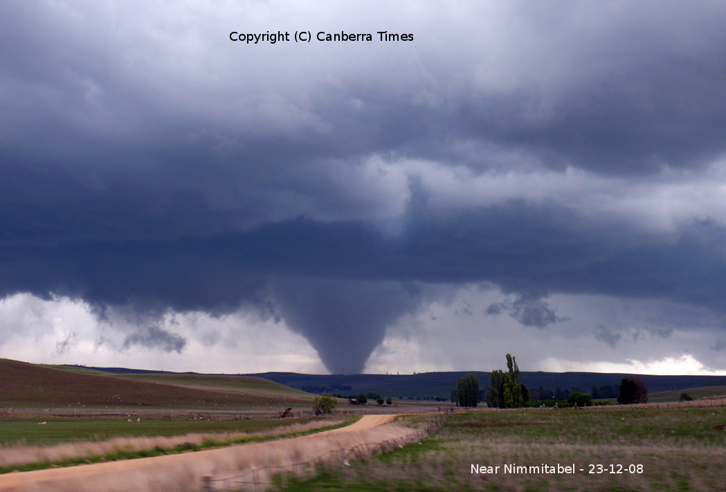
6-1-12, Friday 9am: Blackheath didn't see any major storms last evening although there was a lot of lightning. There certainly were some strong storms across the Central Tablelands last night with a tornado causing damage to boats on Lake Burrendong, the popular holiday area north of Orange. All boats have now been found after a rescue helicopter search and Police, SES and volunteers assisted. Winds reached 90kph in Parkes and also near Trangie where trees and powerlines were brought down. The winds at Lake Burrendong were likely much stronger than 90kph. Tornadoes do occur in Australia although they are usually under 160kph wind speed and only very rarely get as strong as some of the tornadoes in the USA etc. Read more here.
The following link is a strong Tornado that occured in 2008 in Australia, click here for image.