Winter 2013
December 5th, 2013:
This event was a very impressive event for December. Whilst snow only occured in the very highest areas; Oberon Plateau (above 1200M), Sunny Corner and Mt Cannobolas etc, for a summer cold outbreak this was a very notable result. Blackheath saw hail on Thursday afternoon and evening and at just before 8pm, there was definite moments were the cold rain turned to sleet over a fifteen minute period, even though the temperature was 3.6C at the time. The air was not saturated (RH was less than 100%) at this time and this allowed the usual evaporative cooling effect to keep flakes alive in temperatures well above freezing. This typically only happens when there is enough strong instability in the air mass with cold mid and upper level temperatures (where snow is made) and strong down drafts in localised storm cells that push melting snowflakes more quickly towards the surface.
The Wagga Wagga weather balloon sounding on Thursday the 5th was nearly -26C at 500hPa and -8C at 700hPa and almost -1C at 850hPa. That is seriously cold for an outbreak in summer! That would be a quite good reading for September. View the usual photo link for a photo/video record of this event.
A number of places broke their records for low maximum temperatures on this day, here are some of the NSW ones; Wilcannia Aerodrome AWS, 22.9C, previous = 23C. Bombala AWS, 9.1C, previous = 10.6C. Narrandera Airport, 16.9C, previous = 18C. Cobar airport, 20.9C, previous = 21C. Some minima records for Friday the 6th of December are Cobar, 8.1C, previous = 9.1C, Narrabri Airport, 7.8C, previous 10.3C, West Wyalong Airport AWS, 5.9C, previous = 7C.
October 3rd, 2013:
This system was forecast by the models to be fairly cold at the 500hPa level as the upper trough passed over, about -27C, which helped it produce hail showers throughout the day in Blackheath (starting at around 10am) snow showers on the Oberon Plateau and thunder snow on top of Mt Cannobolas at around 10am. There was only a light settling in these areas that quickly melted. The temperatures lower down in the atmosphere were not that cold (barely 0C at the 850hPa level) so surface temperatures across the Blue Mountains were well above zero during the shower activity, so hail was our only result. A fun event after a record warm September.
August 19th, 2013:
Another system that was unremarkable in a sense but with the cold 850hPa temperatures and also at 700hPa, there was enough mid level cloud development to produce some nice snow showers on the Oberon Plateau and even the upper Blue Mountains. The Sydney weather balloon information for Tuesday morning showed about -23C at 500hPa, -12C at 700hPa and about -2C at 850hPa. Whilst that is good in the lower levels, its just not cold enough in the upper levels at 500hPa to produce strong snow bearing clouds, that extend well into the atmosphere. This is why the snow in the Blue Mountains was mostly snow grain type snow, as it was falling from clouds that were fairly low level. There was some nice, larger flakes, especially on the Oberon Plateau, where around 3cm or more settled by late Monday, on the 19th. Blackheath had cold rain, hail and sleet at around 6pm then nice snow showers around 8pm and also 9pm with a light settling at 9:15pm. Will add more details as time permits.
August 8th, 2013:
Not a remarkable event by any means but a pleasant intrusion of cold air graced the tablelands on Thursday morning, the 8th of August, with some light snow around. The Oberon Plateau had a light dusting of snow, or perhaps a little more, by daybreak. Porters Retreat had a nice, light cover and Oberon township had nice snow showers. The road to the top of Mt Cannobolas (near Orange, at 1395M) was closed on Thursday morning after apparent heavy snow there with snow drifts of around 30cm. The actual, settled fall there may have been around 10 to 15cm but this is unclear. In Blackheath there were a few sleety and floaty snow flakes at dawn and again at around 8am but nothing much else to show from this event. It takes a strong SW system to produce snow for our town or anywhere across the Blue Mountains, as southerly events are better for us, even SE winds events. The wind chill in Blackheath was close to -9C at 7am and the midday temperature was 4.5C. It was lovely to feel the chill of the day that has so often been missing this winter. I haven't included a weather balloon sounding from this event or any other details as it wasn't really a notable snow event for the central tablelands but should be noted, nonetheless.
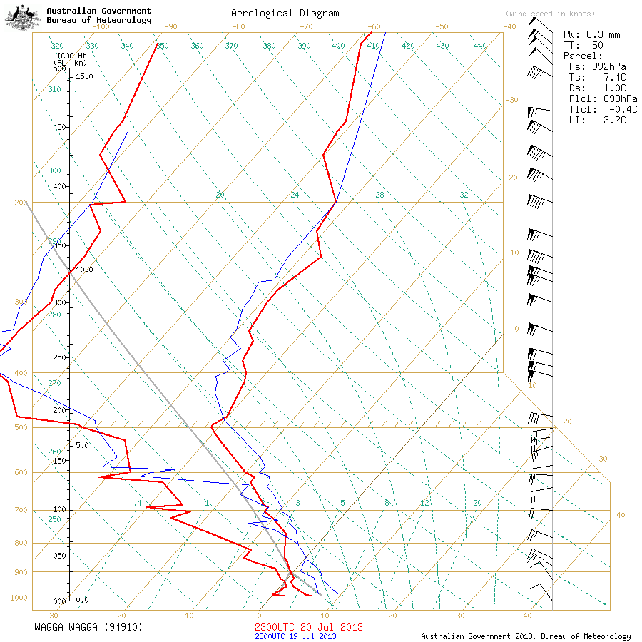
July 21st and 22nd, 2013:
This cold front didn't quite push far enough north to give the Oberon Plateau or Blue Mountains much snow but a cm or two settled above 1200M on the Oberon Plateau on the 21st and a few flurries occured in the Blue Mountains very early on the 22nd, with a light dusting on the ground. The weather balloon sounding for Sydney on the 21st was not very cold through the layers; -23.5C at 500hPa, -6C at 700hPa and -2C at 850hPa. That really isn't cold enough to produce much snow and the relative humidity was not very good throughout the layers as well. Just to the SW, the Wagga sounding was very cold (see link above) and this would have produced excellent snow if that air mass had pushed further north east. Its possible that the flurries Blackheath experienced in the early hours of the 22nd were from the very edge of that super cold air mass that the Wagga weather balloon recorded yesterday.
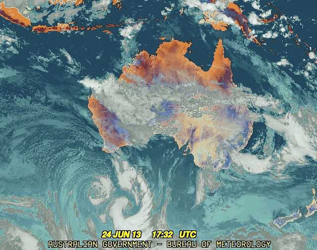
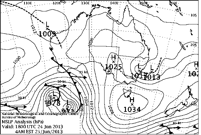
June 24th - 25th, 2013:
Well, we were fearing the worst for June with the strong prospect of no snow for the month. Then, nature surprises us with a fascinating little setup via a coastal trough/low(s) and a fairly cold mid and upper level air mass that produced a nice blanket of snow in areas like Yetholme and Gingkin. A very non typical cold front but it still worked fairly well to produce some snow. It seems about 3cm settled overnight and in some areas this has been mostly washed away by rain. It sounds like Yetholme area still has about 3cm of snow on the ground as of 8am Tuesday the 25th. Barrington Tops had about 2cm that settled and further north at Guyra there was around 1cm of snow that settled.
Whilst the temperatures at the surface/ground level were generally not very cold in this outbreak (typically in the 2C to 4C range) its important to realise that snow can be entrained (dragged in) in locally colder downdrafts in cold air convection clouds and therefore survive the fall to the surface, even if its well above zero degrees. That's why there can be times that its 1.5C and drizzling or 4C and snowing - you need the mid level air mass to be cold enough to produce strong, vertically developing clouds, for snow to fall when its well above zero. I've actually seen snow fall here in Blackheath at 6C but its usually very light and rarely settles. I have seen it settle at 4C under a powerful cold air cell with heavy snow showers but usually to less than 1cm.
This excerpt from Weatherzone forums from Laurier Williams also speaks of some of the contributing factors to this event. More news as time permits.
"The high lapse rate (and therefore instability) between 850 and 700 is significant because this is the snow-producing part of the atmosphere for the CT. Also significant are the low temperatures on the Wagga sonde - 0.6 at 850, -7.9 at 700 and -25.3 at 500 - because these are all in east to southeasterly winds swinging under the developing coastal low which is already stacked close to vertically up to 700hPa and drawing in air from north of the NZ North Island. As has been commented elsewhere, this may be returning cool air from the recent cold blast that affected NZ - I'd have to check some trajectory charts to confirm that."