Winter 2016
August 22, 2016:
Sleet occured across the upper Blue Mountains above 1000M in the afternoon, from about 2pm. Light, wet snow occured at Shooters Hill and Yetholme, although it did not settle very much at all. A low in the mid to lower levels appears to have been the culprit as the air mass wasn't that cold. The low level low seems to have sufficiently dropped the surface temperature, to allow some flakes to survive but it never really snowed properly in the Blue Mountains, just quite a bit of sleet.
August 20, 2016:
Light snow showers occured across the Oberon Plateau on this day with perhaps a cm or so of settling in places. The upper mountains had light hail at times and possible sleet.
August 2, 2016:
The 2-8-16 event was a fascinating system. For about a week leading up to the event, a strong, classic type cold front looked set to arrive in our region - with a nice pool of cold air in the upper levels (500hPa), a solid sub polar jet stream at 300hPa and maybe a nice east coast low developing in the Tasman. This theme remained fairly consistent in each model rendering for a good few days with a surprising amount of similarity in each model output.
Systems 'downgrade' that isn't unusual but the nature in which this system changed was sudden, significant and frustrating.
Suddenly the cold air in the upper levels pulled back and was replaced with milder, fragmented air that wasn't that cold at all. From memory, it was around -4C to -5C at 700hPa and around 0C at 850hPa, not exactly set up for steepling, cold air convection. This changed the whole dynamics of the system and took the east coast low scenario away from us. In the end we had a surface low in northern NSW that remained over land and upper low that interacted with this, as well as a cold front of sorts, like a southerly change, that moved up the NSW coast.
As a result of this, an isothermal layer was present below the freezing level, where the temperature remained pretty constant due to the south easterly cold air being advected into our region, beneath the milder air at 700hPa. I think I am explaining this clearly and please email me, if there is something that can be added here. So, to summarise, it was just cold enough to snow across the Oberon Plateau (a few cm) and sleet occured for some hours in Blackheath, with some lovely snow flakes in the mix at times. It never did fully transform into a snowfall though, as snow mixed with rain is sleet, not snow.
July 5, 2016:
The weather balloon info for this event showed -26C at 500hPa. -8C at 700hPa, 1C at 850hPa, so it wasn't quite cold enough for snow in the upper mountains. Some sleet and perhaps wet snow fell very early on the 6th, in Blackheath. There was light settling on the Oberon Plateau on the night of the 5th, maybe a cm or two.
July 1, 2016:
A fairly weak front but there was sleet and possibly wet snow in the middle of the night (31/6) but nothing settled in Blackheath on the morning of the 1st. Surface pressure was a little high but showers occured on the Oberon Plateau overnight on the 31/6, to perhaps a few cm.
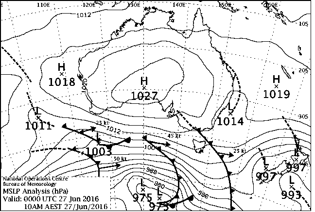
June 27, 2016:
This system was unusual, as it didn't look that potent on the charts, not even looking like a classic front in many ways. It was more just an area of low pressure slowly moving our way, with moderately good moisure associated with it. It had one notably good thing going for it, that was quite cold temperatures at the 850hPa level, of -2C, perhaps remnant from the cold front we had on the 24th. So, any light precipitation that fell, had a good chance of falling as snow.
The weather balloon information from Sydney, showed that it was about -24C at 500 hPa and -8C at 700hPa. So whilst it was not that cold in the upper levels, the mid levels of the atmosphere at 700hPa down to the lower levels at 850hPa were cold enough and sufficient moisture was present for that instability in the atmosphere to produce snow clouds. They weren't steepling clouds soaring many kilometres into the air but they developed sufficiently enough to produce drizzle snow.
It started snowing at around 6am in Blackheath and continued steadily (and mostly lightly) until mid to late morning with about 2cm of cover. Katoomba also saw similar accumulations. The snow fell in calm conditions and was a beautiful experience.
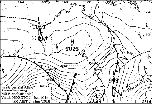
June 24, 2016:
This front was looking somewhat cold on the charts for a week before it arrived. Often the concern is that the system will ridge out or stabilise before it reaches the Central Tablelands and all we will see is a few snow showers in the Blue Mountains. Thankfully, this time the snow fell and fell nicely.
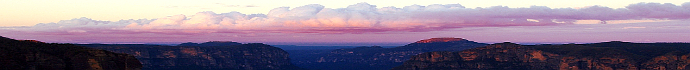
Blackheath had cold rain and sleet showers in the frontal band on Friday morning and then by about 3pm, snow started falling in bursts as the shower activity approached us, via the cold air field. By 1pm the temperature had climbed to 4.3C but gradually dropped to below zero by 4:30pm, as the the cold air mass became established. The Weather Balloon information from the Wagga Wagga area on Friday showed that the temperature at 500hPa was -31C, -11C at 700hPa and -3C at 850hPa. That's a quite cold air mass by twenty first century standards and this allowed the showers to quickly settle to about a depth of 2cm to 3cm in Blackheath, by 5pm. Katoomba had heavier showers and due to this air mass being so cold, they were able to accumulate 3cm to 4cm of snow there. Even Lawson had snow showers.
The Oberon Plateau and places like Sunny Corner had around 4cm to 5cm. Next morning had the more stable air mass still present, so our minimum temperture was -3C with snow still around and the local duck pond near our public pool froze on the Saturday and Sunday.
May 28, 2016:
This system was moderately cold but certainly not snow laden up this way. The Sydney weather balloon sounding for Saturday afternoon showed it was about -26C at 500hPa, -7C at 700hPa and about 1C at 850hPa. So, surface temperatures at the altitude of Blackheath were in the 3.5C to 5C range for most of the day, with a maximum of 5.8C at 3:30pm. Even when some moderately good convective cells passed over town, it just didn't get cold enough for sleet or snow.
Some snow fell at Yetholme and Sunny Corner throughout the day but nothing of note. Cold rain and occasional sleet was the order of the day. Blackheath had a bit of cold rain with occasional specs of ice in the showers. To some up, even though the day felt cold and windy and the upper low and surface low in the Tasman looked impressive, the air mass was just not that cold. More like a late April system.
Today in history was a famous cold front day when a powerful system hit SE Australia in the year 2000, bringing low level snow, about 10cm of snow to Blackheath and a minimum of around -3C. Sadly, this event didn't come close to that one.