

AWS Links


Mt Boyce AWS - A good way to check for snow in the upper Blue Mountains during a cold outbreak. This site typically updates about 15 minutes after each hour but may update more regularly at times. Check the temperature column and make sure it is two degrees celsius or below as rain usually turns to snow at around this temperature. Next, go to the "Rain Since 9am" column and check if it is raining or has rained since the temperature has been 2 degrees or less. Remember, even though you can see flakes falling at above zero degrees, settled snow usually occurs at around 1C or below. Note, don't be fooled during a good snow/cold outbreak when the AWS rain gauge can freeze over and give no precipitation reading.
Mount Boyce Records-Climatology - Temperature and rainfall records and much more.
Katoomba Records-Climatology - Temperature and rainfall records and much more.
Mount Boyce Daily Weather Summaries - On some phones, try selecting 'desktop site' etc in settings, to view the link.
Central Tablelands Daily Weather Summaries - Farm Online Link.
Mount Boyce-Blackheath Page - Weatherzone - The main page for all Blackheath weather info.
Katoomba Daily Weather Summaries - Weather stats and records from Weatherzone. Some phones default to mobile page...
Central Tablelands Daily Weather Summaries - Daily, monthly and yearly summaries.
Mount Boyce AWS - alternative link for obs - Courtesy of Elders. This link should be viewable on all phones although text is small.
Personal and BoM stations - This is a good reference link for personal and BoM stations.
Sunny Corner - Weather Station - NW of Lithgow. Around 1200M above sea level. An excellent, private station. A great resource for cold climate weather lovers, especially during winter.
Katoomba, Narrow Neck Weather Station - Narrow Neck area. 1020M ASL. A private station. Regularly updates.
Mittagong Weather Station - About 40km west of Wollongong. 635M ASL. A private station. Nice way to get an idea of possible snow heading to the Oberon Plateau. During showers, add around 0.6C for every 100M of higher altitude on the OP.
Mt Kaputar - Weather Station - 570k NNW of Sydney. At around 1475M above sea level, this is a handy tool to view airmasses heading towards the Guyra area on the Northern Tablelands. You can get a good indication of the temperature at 850hPa, which is an important lower atmosphere measurement for cold airmasses.
NSW and Australian Weather Stations - See links above the NSW graphic for other states.
Rainfall and River Conditions - Handy resource to check rainfall, in places like Shooters Hill.
Tasmania Weather Stations - Mt Wellington AWS (click on the Hobart area) gives a good idea of the temperature at roughly 850hPa. This is an important level in the lower atmosphere to help determine cold airmass potency. Look for AWS temps in the -1C to -5C range during stronger cold outbreaks.
Katoomba Council AWS - This site updates every minute or so. Please note, this unofficial weather station is situated at the Katoomba Council building and it usually records overly hot temperatures in full sun conditions. However, it is handy for wind and rain observations and also night-time readings. Its also very useful during winter cold snaps when cloud and wind allow its temperature readings to be more accurate.
Weatherzone climate data for Mount Boyce AWS - Lots of detailed climate data here.
Weatherzone climate data for Katoomba - Lots of detailed, long term climate data here.
Central Tablelands Daily Climatic Data for the current month - Another fine presentation from Laurier Williams at Australian Weather News. Head to the links at the top of the table for a one year archive. For national data, go here.
AWN Synoptic Charts - View the latest synoptic reports for our area (and many others) in graphic form at Australian Weather News. This link can be out of date at times.
Rainfall Accumulation Graphs - Some excellent charts from Andrew Miskelly.
Blackheath Rain Bulletin - Worth a visit if Mt Boyce AWS is down. Scroll down to find Blackheath.
Antarctica and Sub Antarctica - Special Feature
Macquarie Island AWS - Always nice to know how Macquarie Island is going as its technically part of Tasmania.
Macquarie Island Climate and Macquarie Island Webcam - It snows on about eighty days a year there with about six falls of around 10cm each year. So Australia actually has a region that is snowy at sea level.
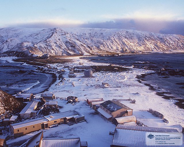
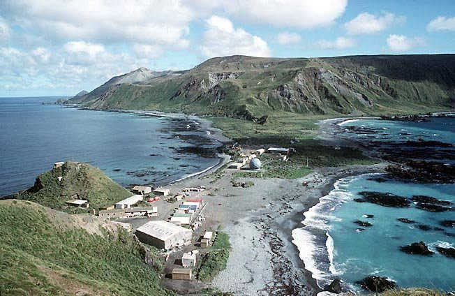
Macquarie Island under snow and Macquarie Island fair weather day
Dome A Temperature - See maps on this link for this extremely cold place in Antarctica.