Winter 2010
These reports are done as time permits. Further information will be added to them periodically.
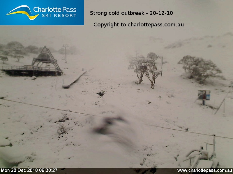
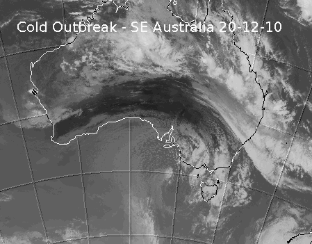
December 20th, 2010:
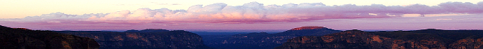
Whilst we didn't see much from this impressive summer event in Blackheath, I am reliably informed that it snowed for about an hour (6:45am to 7:45am) at Mt Trickett on this morning. Other areas like Mt Trickett also would have seen snow at around the same time but no settling occured to my knowledge. Blackheath had some icy precipitation at this time but it was soft hail and not quite moving into sleet and definitely not snow. We had windchills of -5C just before 1pm which is amazing for summer with winds gusting to 70km/r. The temp eventually climbed into double figures by the afternoon but it wasn't above 11C for long.
It got down to 3C in my screen in Blackheath at 6am and currently at 8:15am its 8/8 overcast with light, spitty drizzle and 3.4C. Amazing for summer. I was expecting in the 4C to 5C range this morning but hoped for a little colder. Not sure how the BoM ever thought it would stay at 7C?
October 16th, 2010:
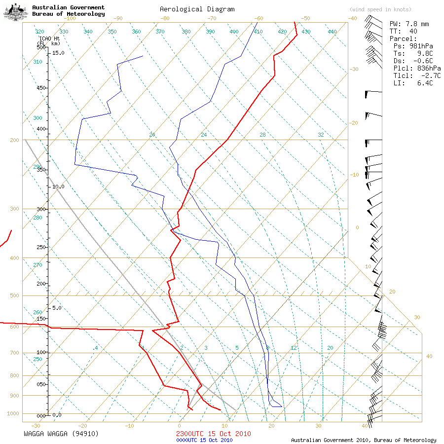
What a great system this has been. Not any heavy settling to speak of but the mid and lower levels of the atmosphere are some of the coldest I have seen in years. The Wagga weather balloon sounding for this morning tells us that the temperature at 850hPa (about 1300 metres above sea level today) is around -4C and the 700hPa temp is around -14C. That is seriously impressive cold. Sure, the 500hPa upper temp of only -26C isn't grand but with those mid and lower level temps so cold, this has been the reason snow is still falling well past midday in Blackheath.
At 1:30pm we had a ripper snowy burst that started to settle but the spring sun and the time of day has always melted any light settling very quickly. If we had colder upper temps with this event (and better mid level RH) there would have been a few cms on the ground in Blackheath, at least. NB: You do need quite a bit of moisture as well as serious cold for snow to settle in October - I only recorded 2mm on the 16th. It has been snowing intermittently in Blackheath since before daybreak with some quite heavy bursts at times. Of course, places like Sunny Corner have had nice settled snow as well, with the better moisture levels and even colder temps out that way.
Reports from Hazelbrook had it snowing for a few minutes at around 9am today at only 630M ASL. A report from snow chaser Ben at Shooters Hill states, 'Snow started pelting down around Shooters at 8:30am. I just hung around there till 10am and let more snow settle as heavy snow shower after heavy snow shower came through, making the cover around 5cm, with 10cm-15cm drifts in sheltered areas'. Be sure to check out the snow videos on the photos link above for your snow fix.
This afternoons Sydney weather balloon sounding clearly shows this system weakening now, even though it is still cold and windy at the surface. The 850 hPa temps have clearly warmed to about 0C which converts to about 4C at the surface and also the 850hPa heights are now higher as well. The relative humidity was dying right off during this sounding as well and more so at 6pm. So what does all that mean? It means that the cold front is loosing its grunt and snow showers are less likely tonight. More info as time permits.
NB: It seems that Mt Boyce broke its record for the coldest ever maximum for October, with the new record now set at 5C. The old, no longer operating Mt Victoria site (with records going back to 1872) had its coldest day of 5.8C recorded in 1966, so a maximum of 5C in Blackheath for the 16-10-10 is impressive indeed as the 1960s was a cold, snowy decade. Its also important to note that the new record of 5C was achieved at the 9am reset on Sunday, so the new record could have been 4.7C (reached during late Saturday afternoon) if we were a bit luckier. The Mt Vic record was also set on the 3rd of October 1966 (I was born in a cold year it seems) so to break that on the 16th of October, quite late in the month, is a very good result.
Oberon also had is lowest ever minimum (-3.2C 17th) after a -3C the previous day also breaking the record but there is still some questions on the validity of these minimums for cold air avection readings. Gulgong appears to have recorded its coldest October maximum in 34 years with an 11C as well. Orange Airport looks to have beaten its 41 year record with a 5.5C on the 16th too.
Blackheath also recorded -14.9C windchill on the 16th and for a large part of the day it was close to or under -10C.
And thanks to Ben from Weatherzone forums alerting us to the fantastic cold outbreak at Macquarie Island today, with good snow indeed settling at sea level. That could auger very well for coming winters, to see snow falling down there at sea-level, so late in the season.
August 26th, 2010:
Another system that was quite marginal for temperatures throughout the various layers of the atmosphere. I don't have the sounding information on this computer to view at present but as the system moved NE through NSW it did appear to weaken. Upper temps were only around -27C to -28C which is okay if the lower level temps are cold but they were not. 850hPa temps were only just below zero and if it wasn't for the lower 850hPa heights with this system, we may not have had any snow for the BM. Still, nature gave us something to cheer about this time, just. Nice sleet and snow showers occured this afternoon and evening in Blackheath - see video in photo section - and quite heavy sleet and wet snow settled just after 7pm but melted not long after. Flakes up to fifty cent piece size were falling at times. Not quite cold enough to settle a lot though. The Oberon Plateau had nice settled falls above 1000 metres where even Oberon township saw a solid cover on the ground.
August 21st, 2010 - Election Day:
This system surprised a little. For once it was actually colder than forecast. Early bird voters at the local school hall at 8am saw sleet falling in temps of about 2C. More sleet occured intermittantly throughout the morning but never turned to real snow. The Mt. Boyce AWS RH at this time was around 70% and even lower, which is part of the reason the flakes survived the mild temps of around 4C then 5C by midday. Its effectively an evaporative cooling effect on melting snow - keeping it alive. Snow grains then began here at around 11am, then back and forth to drizzle as the RH got a touch higher. Snow grains sound like sand being poured onto the roof. Quite a bit of it occured at 1pm and you could see the heavier shower activity on Terry Hills radar at this time. Some light snow occured at Sunny Corner and the Oberon Plateau this morning - no reports of much settling yet.
No sago snow over town yet, that is formed by stronger convective clouds which haven't made it to Blackheath...as at time of writing. Snow grains are frozen drizzle and they are only surviving today as the surface air is relatively dry and those 850hPa temps are just cold enough. The Wagga sounding this morning is pretty cold actually with around -27C at 500hPa, -11C at 700hPa, and about -2C at 850hPa. The Sydney sounding (-25.5C, -6C, 1C) dries out in the lower levels and is not as cold but that may have been recorded just before the best part of this air mass arrived.
August 12th, 2010:
This system was never overly cold but there certainly was plenty of moisture with it. Sleet occured intermittantly in Blackheath from about 3am to 5:30am early Thursday with some genuine flakes briefly mixed with the rain but no real snow flurries. It was 3.7C at midday in Blackheath. Reports for Thursday morning were showing good snow across the Oberon Plateau, up to 10cm at Shooters Hill and maybe more at Mt Trickett. A snow chaser reported about 5cm on the ground this morning at Edith and that he wasn't able to make the drive to Mt Trickett. The dynamic nature of the surface low with nice upper support in the form of enough cold air and mid level moisture, gave this system enough punch (just) to deliver good, wet snow. Curiously, Sunny Corner didn't get any settling (as of 8am today) although sleet and snow showers occured there. The Sydney sounding this morning shows -28C at 500hPa, about -8C at 700hPa and 1C at 850hPa. The airmass over the Oberon Plateau would have been a bit colder than that. Remembering that the lower levels (850hPa) don't need to be as cold as the 850hPa heights are lower in events like this, snow was then able to survive to the surface out Shooters Hill way. More info as it comes to hand and I have time to type it up.
August 1st and 2nd, 2010:
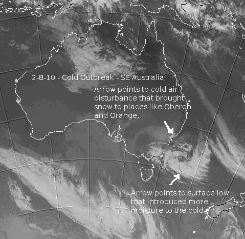
I made a dash out to Shooters Hill area on Sunday the 1-8-10. I parked near the cemetery as its nice and protected and only slightly lower than the actual Shooters Hill radio towers. At 3:30pm spitty showers commenced with a temp of about 7C. By 3:45pm moderate shower activity was occuring with a temp of 6C. By 4:04pm there was large drops of rain and melting hail. At 4:13pm sleet and rain was in the mix with a temp of 3.3C. A minute later heavy sleet started as the temp dropped to about 2.7C. 4:30pm saw strong sleet showers scattering the ravens in the cemetery and by 5pm it was full blown snow with a temp of around 1C.
I then moved up to the Shooters Hill towers and caught up with Shayne there where it was snowing nicely. We had a great chat about all things weather and snow whilst watching the snow get generally heavier. At around 6pm Ben arrived and there was by now about 2cm to 3cm in settled spots away from the wind blown 'car park'. Rhys arrived at about 6:30pm and the falling snow was lighter by then. The Mt Gambier sounding yesterday showed this air mass to be around -32C at 500hPa, -12C at 700hPa and about -2C or lower at 850hPa and whilst the airmass was not as cold this far north it was still pretty good.
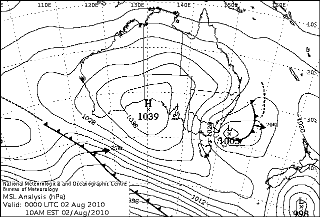
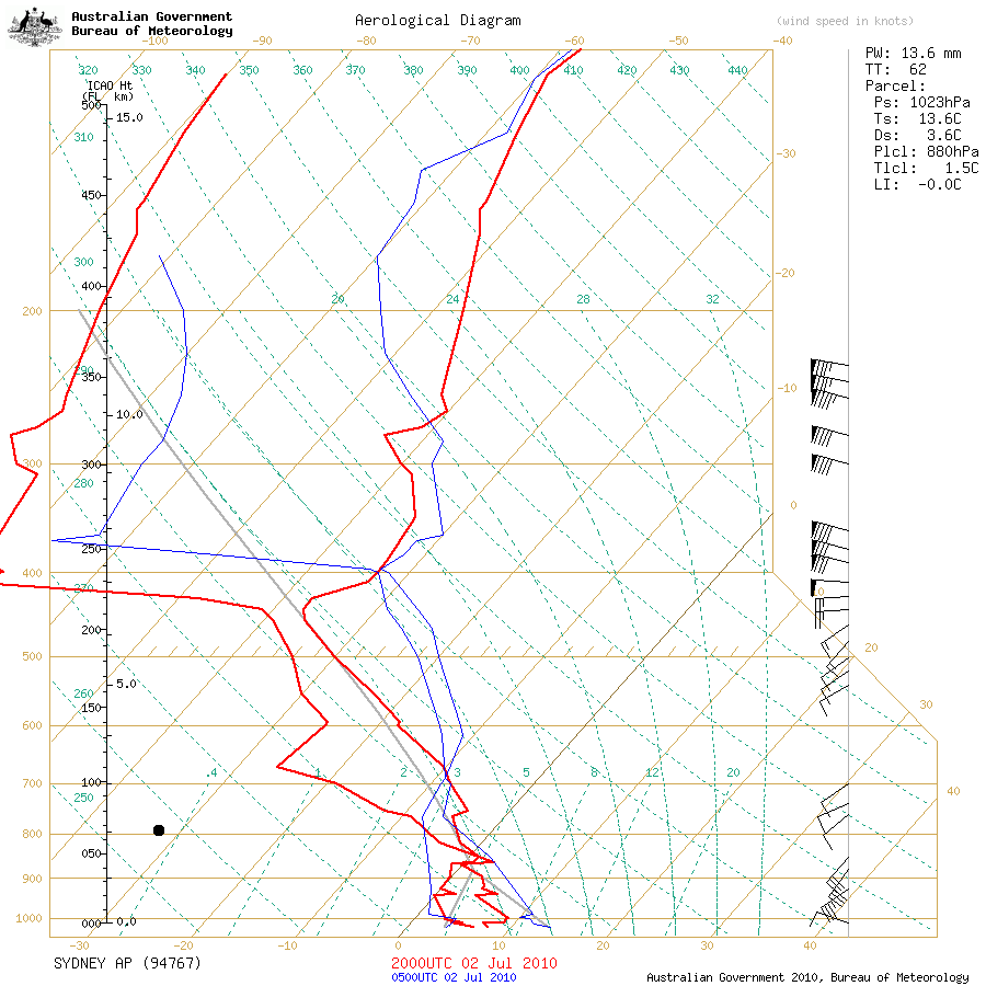
Various places across the CT saw snow late on Sunday and on Monday (2-8-10) as the developing surface low in the SW Tasman Sea introduced more moisture into the cold outbreak setup. This low also introduced warmer maritime air by later on Monday, ending the snow. Blackheath still had snow falling just before midday on Monday which had been occuring quite regularly since about 6am. It was quite novel to go for a walk on the local oval at 11am and to have light snow falling. The Mt Boyce rain gauge sadly has not been recording during this event. Snow never settled here though. Other places like Lithgow, Rydal, Sunny Corner, Orange and Oberon also saw snow with slightly better falls in those places than Blackheath. Snow was even observed as low as Leura and Wentworth Falls although it was very light there.
Below are some interesting thoughts by Laurier Williams from Australian Weather News, on possible reasons for the snow being quite 'sticky' with this event, even when it fell high on the Oberon Plateau. There was also only a fairly small difference in temperature from Shooters Hill to Blackheath. This was a cold air mass and myself and others were initially surprised that the snow wasn't that dry. A saturated atmosphere may well have been the reason for this and the similar temperatures in Blackheath and on the Oberon Plateau.
'I think in a saturated environment you will get wet snow some distance below zero because (a) there's a low temperature gradient above surface, (b) any variations in the airmass/airstream are therefore more critical, and (c) there is more opportunity during descent for snowflakes to slightly melt and make contact with other forms of frozen and unfrozen moisture that stick. Conversely in a drier environment you may even get dry snow above zero because (a) there's a higher temperature gradient above surface, (b) therefore airstream temperature variations are not so critical, and (c) because the snowflake remains frozen until it is at or just above surface, there is little or no opportunity for contact with other melting flakes. - Laurier'
Click here for Lapse rate info
July 15th, 2010:
Light snowfalls again occured across the Oberon Plateau early this morning with a few cm on the ground above about 1250M, even the Oberon township saw snow showers last night but not much settling to my knowledge. Reports from snow chasers at Weatherzone forums indicated a few cms at Shooters Hill by dawn and similar amounts at Mt Trickett and Mt Bindo. Blackheath saw sleet and some wet snow between about 12:45am and 1:45am. Thanks to Mr NASA for his bleary-eyed, local reporting. This system followed the pattern of cold fronts this year with the bulk of the cold air mass staying south of the Oberon Plateau and the Blue Mountains. Just to our south, the Nowra sounding this morning showed -29C at 500hPa, -10C at 700hPa and about -1C at 850hPa. That would have probably given us snow in the upper Blue Mountains, maybe even a settling, if that colder air had reached us.
In contrast, the Sydney weather balloon sounding this morning gave -25.5C at 500hPa, -12C at 700hPa and about 0C at 850hPa. So, over the Blue Mountains area we had not very cold air in the uppers, cold air in the mid levels with passable moisture but not much cold lower down to keep the snow 'alive' as it reached us. We really need 850hPa temps of about -2C so by the time the snow reaches us at about 900hPa, it hasn't melted to sleet or rain. Upper temps need to be at least -27C but are better at -28C and colder. I may add more to this report as time permits.
July 2nd, 2010:
Light snowfalls occured across the Oberon Plateau on the evening of the 2nd of July. Sunny Corner also had a settling on Friday night and some brief snow showers the next morning. Accumulations were generally confined to above 1200 metres ASL as the temperatures in the lower levels of the atmosphere were not quite cold enough for snow. The Sydney sounding link above shows this well, cold in the uppers but lower down it was not quite cold enough. Moisture was certainly ample and if it was a degree colder, Blackheath could have seen 2cm on the ground but not to be this time. Thanks to 'snowmi' from Weatherzone forums for the excellent photos and thanks also for the email reports from Oberon Plateau residents and areas nearby - its great to hear from you.
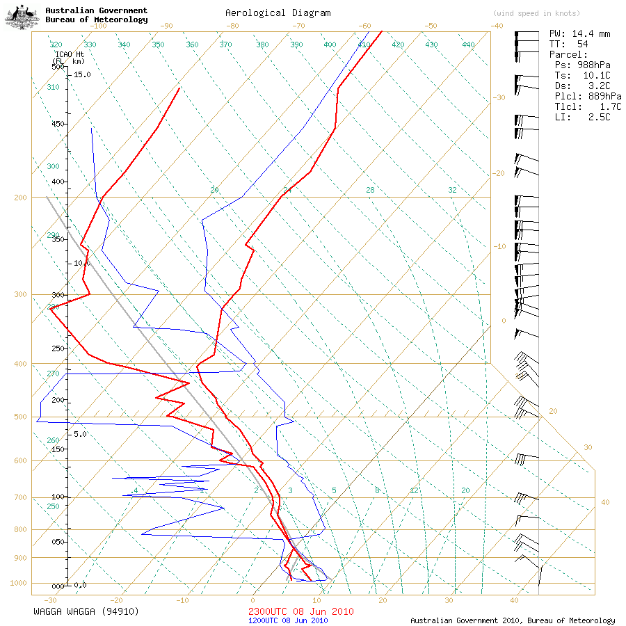
June 9th, 2010:
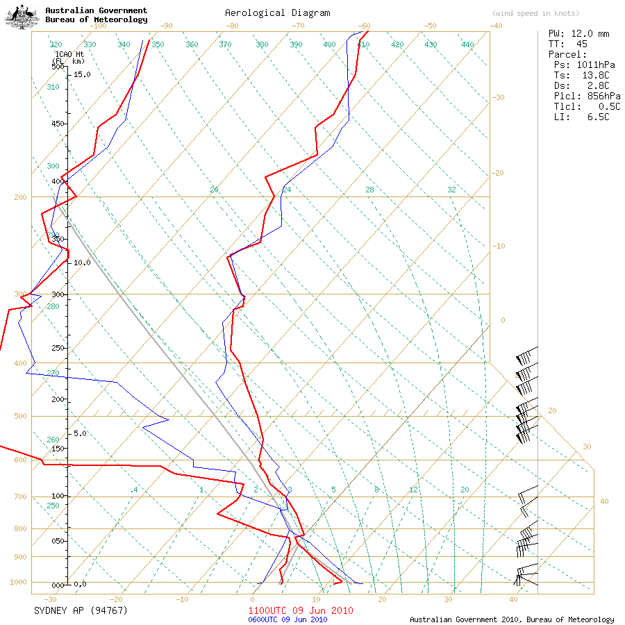
Light snowfalls occured on the Oberon plateau on Wednesday. The Wagga Wagga sounding from Wednesday morning showed an air mass that was fairly cold although not overly so. 500hPa temps were around -28C, 700hPa temps were about -9C and 850hPa temps were about -2C. For those that are new to weather watching, weather balloons are sent into the atmosphere by the BoM from various areas of Australia each day and give a great profile of cold air masses in this context; including temperatures in the different layers, relative humidity and wind speed and direction. Forecasters use these readings to formulate opinions on what the weather may do for a given period. For the extra keen among us, you will notice that there is a lack of any southerly jetstream in the Wagga sounding at around 300hPa. This makes it hard for cold fronts to survive long at our lattitude. This is a feature that has tended to be missing more often over the last decade or so.
If that Wagga Wagga air mass had made it this far north, we could have been in business for some nice snow in the Blue Mountains but alas, no luck this time. You can see by the Sydney sounding last night that the air mass was notably milder up this way. No snow this morning in Blackheath apart from a few tiny snow grains on the recycle bins.
Just an update on this, as of 10/6/10 at 8am. I did see quite a few snow grains in shady areas near the tennis courts, when taking the dog for a walk and my rain gauge has 1.2mm in it, when there was only a trace in there last night. Sleet and snow grains appear to have fallen in Blackheath overnight. There is a windchill of -10C this morning (10/6, 7am) and the air temp is just over 1C. More information in this report and further photos will be added as I have time.
NB: It was nice to catch up with a couple of other snow desperados yesterday at Shooters Hill. Nick Moir and Rhys were out there, also looking for the first flakes of the season. Nick's a talented photographer from the SMH (Google him and you will see what I mean) and is a keen weather watcher. Ellie Harvey from the SMH did a nice story and pretty much reported exactly what I said. Thanks guys.