Head to the experimental blog for all of the latest
Local Weather News in 2011! Of course, the main site still exists for comprehensive weather information.
16-12-10, Thursday, 7am: Would you believe there is a slight chance of sleet/snow for the Oberon Plateau by around Monday. Head to the Cold Outbreak News link above, for a more detailed rundown.
14-12-10, Tuesday, 7am: Crikey, that is a strong cold change for summer, due in by about next Monday. At least Blackheath may get an 'okay' day or two for the summer opening of our pool this Saturday, before the colder weather strikes. There is even a chance of some sleet or a few flakes above 1200M on the Oberon Plateau. I say a slight chance, as it is summer of course and the most likely outcome is chilly, windy with a bit of rain. Watch this space, I will update if it improves or even if it stays the same on the models.
13-12-10, Monday, 2pm: 188.2mm for November from my gauge with 137.4mm so far for December. That's well over 300mm in the last six weeks, which is a lot of water. Weaker troughy weather will gradually develop by tomorrow through to Thursday with the best chance of decent rain being on Thursday. It will be nothing like we have had in recent weeks at this stage but some showers could be moderatly heavy on Thursday. Then, a reasonably good chance of fine weather on Friday and Saturday and then another trough should move through by Sunday.
8-12-10, Wednesday, 9am: Another 10.6mm since my last post, which has consisted mostly of lighter showers, which now takes us to 207.6mm from this event. The next system approaching is set to deliver more intense shower activity, firstly in western NSW today, then slowly moving further east as we approach Thursday. Western areas could see 100mm or more from this setup although I wouldn't expect that much in the Blue Mountains but there is always a slight chance it could eventuate. Our thoughts go out to the many folk on properties and in regional areas affected badly by the flooding. This next rain event is the last thing they need. The weekend at this stage isn't looking too bad but the Blue Mountains could be on the south eastern edge of the trough, so there may still be some showers around. Its a bit touch and go in this regard.
5-12-10, Sunday, 8am: Another 20.7mm for the last 24 hours, which now takes us to 197mm from this event.
4-12-10, Saturday,7am: To 7am today, we have now had a total of 176.3mm from this event (from my gauge) after some more heavy rain late yesterday. 38.8mm recorded for my gauge from 9am yesterday to 7am today. I certainly felt 50mm was possible from this event and just maybe 100mm but 176.3mm is a big result.
1-12-10, Wednesday, 7pm: From my home gauge: 49.5mm since 8am this morning to 7pm tonight, 68mm for the forty eight hours prior to that. And a total thus far of 137.7mm since Saturday night. Amazing.
1-12-10, Wednesday, 8am: More than 85mm has fallen into my gauge since this event began on Saturday evening. More rain will certainly fall today although the system should gradually weaken by tomorrow, at this stage. There is still a good chance of lingering showers at least until Saturday although it shouldn't be as heavy as today. According to weatherzone.com.au news, it has been the wettest spring on record across Australia with an average of 160mm falling. This figure is about 100mm more than last year's average.
29-11-10, Monday, 5pm: Moist easterly winds feeding into a trough setup will be the feature of this weeks weather, so if you are a bit sick of the damp weather, you might need to move away from the east coast for a week. We could get 50mm from now until next Sunday. Always hard to tell where the heaviest showers will occur though, so we will have to wait and see.
11-11-10, Thursday 7am: What a close strike we had last night! It was about 10pm or so and very quiet, apart from a few distant rumbles, then there was a 'Click, click - BANG!' One of the closer ones I've seen. We get quite a lot of close strikes up here, being so close to the storm bases. One of the best I've had was when a strike hit a church and then a little lick blew my tyre out. The tyre had this black slash across it. The one that hit last night seems to be a bit of a semi-regular spot for strikes. There's been a couple of dozen there, that seem right outside the window, over the years. You can read a bit about this clicking sound, at this link.
10-11-10, Wednesday 9:30am: The Blue Mountains has been one of the few places to miss out on storms over the last two days and if you like your storms you may have better luck today. Mid level wind shear appears to be sluggish again (sadly, the Sydney sounding has no wind indicators today) but instability looks okay and dew points are creeping up nicely. There's more sunshine today too, to help things. Fingers crossed. If you want to keep up with some of the recent storm activity in NSW, then head to the You Tube page of Michael Thompson. He is one of the really experienced chasers and provides some good info on storm development as well.
10-11-10, Wednesday 9am: 153.7mm was the recording for my gauge in October after we only recorded 45.6mm for September. My October reading was notably higher than the official Mt Boyce reading of 94.2mm for the same period. That isn't unusual, especially when easterly systems are occuring. The Mt Boyce average for October is 66.8mm. Katoomba officially recorded 167.8mm for October and their average is 90.9mm.
10-10-10, Sunday midday: I've recorded over 100mm in my gauge so far this month, that's an excellent start to October after we had only 45.6mm for September. September wasn't bad though, compared to some years. Head to the Cold Outbreak News link above to read about a potentially strong front due in around this Friday
4-10-10, Monday 9am: The trough off the coast has certainly delivered good rain to Blackheath and the Blue Mountains in general. To 9am yesterday my gauge recorded 29.5mm and to 9am this morning there is another 41mm in the gauge. 70.5mm thus far is a great result. Mt Boyce is a touch lower for this event but that isn't unusual in an easterly system. There will be more showers today, possibly moderately heavy at times but then a gradual easing into tomorrow.
30-9-10, Thursday 9am: A -1C in my screen this morning and the grass temperature would have been -3C or more, quite possibly. Hopefully the apricot tree in our backyard hasn't suffered too much damage. Sunny Corner reported a -3.6C (they didn't have the evening cloud out there) with a grass temp of -7.9C and a grass alcohol of -9.9C. We had a bit of soft hail, harder hail and icy rain last night but it was only light and intermittent. Some nice icy precip at times though.
17-9-10, Friday 9am: Macquarie Island has copped a lovely polar blast overnight. Lets hope the cold weather in Tassie and further south augers well for some colder winters up this way soon. There's a moderately good chance this will start to happen next year but until it happens, its only theory. See the Macquarie Island snow cam here.
16-9-10, Thursday 10am: Apologies that posts here are sometimes few and far between, life takes over at times...This link was emailed to me recently and its an interesting read. I don't have strong views on Climate Change and its causes although I am aware of the theories and have spoken to climatologists about them occasionally. It certainly interests me a good deal but time constraints (running websites and life in general) have not made it possible for me to study it in depth...yet. View this article here.
4-9-10, Saturday 9am: This low/trough system moving across NSW has already delivered 15mm to 9am today from my gauge. Rates will be higher further west but we could still see another 15mm today or maybe more in Blackheath. It will be windy today and possibly very windy tomorrow.
4-9-10, Saturday 9am: 65.1mm was my rainfall accumulation for August from my gauge with 41mm from the Mt Boyce gauge. Why the difference? Its not uncommon to have differences over a few kilometres and the Mt Boyce gauge is also more exposed to strong winds so this can effect what falls into the bucket - especially in windy August. I also think the Mt Boyce gauge was down for a while this month? Mt Boyce averages for this month were a little colder than average too with 9.8C for maximums (-1.5C below) and 1.9C for minimums (-1.2C below) but remember Mt Boyce is a 'young' station. Katoomba was closer to the long term average for max and mins at 11.2C (0.1C above) and 2.7C (-0.5C below) respectively but this station has been moved many times over the decades so the records need to be considered in that light. Its also in a warm spot near concrete and bitumen and high on a hill, away from cold air drainage. Rainfall from the Katoomba station was 65.9mm for August.
16-8-10, Monday 11am: Some nice hail storms yesterday passing over Blackheath but it was not sleet. Too warm for that and sleet is snow mixed with rain not hard ice. A few times yesterday saw hail covering my yard quite well, in the 5mm size or a little larger. The wind has been strong too, with gusts nearing 90km/r overnight. There is a slight chance of Oberon seeing a bit of sleet/snow this evening but its only a slight chance, so I haven't mentioned it in the winter link. Its not good for snow prospects, to see tropical Australia heating up so fast at present, so we will have to cross our fingers for a strong winter system or two before a suddent rush into spring.
29-7-10, Thursday 11am: This latest news article from Weatherzone is interesting (The ABC is the story source) and slightly better than the similar SMH one, in my opinion. There is no doubt the world has warmed and has continued to warm. Climatology is not where I spend most of my 'weather time' so I will leave it to the article below to describe the situation. On a personal level, I am curious to see if the significant solar minimum we had in 2008 and 2009 will impact on our weather/climate by later this year and into next year.
I don't have strong views on what is causing the warming of the world climate, I am aware of the theories but my opinions are not strongly and thoroughly researched due to time constraints. I am starting to wonder though, just how much of this climate change may be caused by humans. The next decade will show us pretty clearly what is happening, IMO. In the mean-time, its highly important that we should look after this precious earth, no matter what the causes of the warming are. Live as simply as we can is my approach.
Read about it the above-mentioned article here.
22-7-10, Thursday 9am: Its been a benign winter for fronts again this year, even worse than last year so far. From my records, since the 1950s, it appears that we have not had two very bad years in a row like this. It could change in August/September though, lets hope. We had 66.2mm of rain from my gauge for June and so far in July, we have had just over 30mm.
4-6-10, Friday 10am: This current surface trough on the coast has given my home office gauge a total of 45.5mm so far this month. A very nice start to June. The Blue Mountains tends to benefit more from these events than areas further west. So it can feel quite cool here, like a typical winter but in reality there is still a lack of classical fronts from the SW, so no snow yet or the typical frosty mornings we are used to. I feel sorry for the ski fields, this type of weather pattern, whilst chilly for us, does nothing for their ski season.
4-6-10, Friday 9am: 67.8mm from my gauge for May, which is a great recovery after so little rain for most of the month. That result is better than the short term average from the Mt Boyce Station (53.3mm) but Katoomba's May 2010 total of 79.6mm was well below the long term average of 101.5mm. Just a reminder for weather data enthusiasts out there, if you are taking your readings from the Mount Boyce AWS and then deriving your averages from that, it wont be completely accurate. The publicly available Mt Boyce data only gives the temperatures on the hour (sometimes per half hour) so you are possibly not getting the coldest or warmest temp outside that time.
27-5-10, Thursday 7am: 33.5mm from 9am yesterday to 7am today from my gauge and that should pretty much be the end of this system apart from a few lighter showers. A very good result. 53.8mm is now my total thus far for May, a great improvement on recent weather patterns for sure. A brief respite today of sorts then we will move back into another system for the weekend that could be just as strong. It will all depend on how and where the surface low/trough develops and what sort of upper cold pool occurs.
26-5-10, Wednesday 4pm: Well, nature has finally given us a burst of wild weather today! A nice, tight little low/trough in the Tasman is generating plenty of shower activity for the city basin and also the Blue Mountains. Check out the radar and satellite imagery for some nice action. This activity should ease by tomorrow but not before dumping down more rain tonight. If you want to check out the best web cam in Sydney tonight, have a look at the State of Origin league match on Channel Nine, they could be playing in a pool by 8pm...
12-5-10, Wedneday 5pm: Thanks for the regular flow of emails I get from all of the colder climate lovers out there, its always nice to hear from you. There are people from all walks of life that send messages through and each one of them is valuable and interesting to me. Take heart weather lovers as I think the weather is about to break soon. The BoM has now declared the ElNino officially over! That in itself is a good sign and computer forecast modelling is now showing a dynamic pattern that could potentially develop over coming weeks. No certainty yet at all but the potential is there. Fingers crossed for some wild and woolly weather soon.
22-4-10, Thursday, midday: Have a look at these images from Eyjafjallajokull volcano in Iceland. Simply stunning. Its unlikely that any ash from this eruption will cool the southern hemisphere climate like Mt Pinatubo did briefly in the 1990s.
20-4-10, Tuesday 6pm: Its approaching the time when cool/cold changes start to effect the SE of Australia. Anzac day is typically the turning point for me, when I start to look for better and stronger cold fronts coming our way. This is just a guide of course but its the time of year when patterns generally start to become more wintery, if not completely wintery just yet. The indicators this year for winter are looking pretty good but of course, that's all they are really. Nature will do as she pleases, as we know. Statistically, it would be hard to have another shocker of a winter like the one we had last year so fingers crossed for this year.
There are a number of encouraing signs for this winter but I wont make too many comments just yet as its still very early days. We could see a windy, cool change by around Sunday but as usual in autumn, the models are chopping and changing a fair bit. Its nice to see those frontal systems getting organised in the southern ocean.
10-4-10, Saturday 8pm: The Oberon Plateau and areas nearby (Bathurst/Orange etc) could be in for their first frosts of the season by around Tuesday and they could continue for a couple of days or more. Blackheath and other upper mountains towns above around 1000M could also see frosts although our minimums wont be quite as low as the other areas mentioned. Contrary to what is sometimes believed, the Blue Mountains is not generally a heavy frost area due to most towns/villages being settled on the ridge-line. We still get plenty of light frosts in winter but not often to the extent of the heavy frosts in places like Oberon, Bathurst and places like Crookwell and even Armidale, Walcha and Guyra etc. You can see incredible frosts in these areas, sometimes leaving reedy grass and trees covered in ice around a cm thick.
Have a look at this 2008 ice photo from the northern tablelands, an area that can be much more prone to ice than the Blue Mountains. This one is also a ripper.
6-4-10, Tuesday 8:30am: After 49.1mm from my gauge at the end of March (94.2mm was my March total) we are now due for our next burst of wet weather with an approaching trough. Its always hard to say exactly how much will fall over your house in Blackheath but I would rate it a 60% chance of shower activity this afternoon/evening and into tomorrow. Falls could be moderately heavy if convective activity focuses on our area. Satellite imagery and radar loops will provide the details later today. You can already see the instability just to our NW on IR sat loop.
29-3-10, Monday 8:45am: Well, its been a quiet three weeks on the weather front in Blackheath with only 8mm in that time from my gauge. We are running well below the March average (33.6mm has fallen so far, officially) but that should change slightly over coming days just before the month ends. As I type, there is nice shower activity moving in and we should see more tomorrow.
7-3-10, Sunday 3pm: 318.7mm fell in February from my gauge and most of that occured in the first week of the month although there was some handy shower activity later in the month. 212.1mm fell in January so that is a total of 530.8mm in the first two months of the year. Using the longer term figures from the Katoomba obs station, the average maximum temp for this February came in at 22.7C (0.3C above the long term average) and the monthly average minimum came in at 14.8C, which is 2C above the long term average. Rainfall for this month so far from my Blackheath gauge is 27mm with more falling as I speak.
11-2-10, Thursday 8am: A quite strong system looks to be developing by around Saturday. Just how strong and how wet it will be should be clearer by tonights models. Ahead of that potential, we have a moderately good prospect of storms for today and tomorrow.
8-2-10, Monday 1pm: Another 39.7mm to 9am today, a little more than I expected actually. That takes our total so far for February to 284.6mm. Some light drizzle has fallen since 9am but not a lot.
7-2-10, Sunday 4:30pm: Another 25.4mm in my gauge from 9am yesterday to 9am today which takes the February monthly total so far, to 244.9mm. Add that to the 212.1mm in January and we have had 457mm this year. We have had another few mm since 9am but nothing like the intensity of recent days, although it does look like we could get some more reasonable totals overnight.
6-2-10, Saturday 1pm: From 9am yesterday to 9am today, we had another 71.5mm. 219.5mm has now fallen in my gauge since the beginning of February, very impressive indeed but certainly not record breaking. The total for the year is now up to 431mm from my gauge. These showers should slowly ease over the weekend but there could still be moderate to heavy showers today. It could still be unstable tomorrow but the intensity of shower activity should be less in our region. No beautiful sunshine days just yet although Tuesday looks okay at present.
4-2-10, Thursday 8am: 212.1mm was my monthy rainfall reading for January and that rain has certainly continued into February with some heavy showers over the first few days of the month. From 9am yesterday to 8am today, we have had 57.5mm. The total since the beginning of February is now 108.5mm and rising.
28-1-10, Thursday midday: Plenty of storms passed over Blackheath yesterday, I counted eight storms from 3:30pm to 10pm. The first one had hail to 1.5cm that lightly covered the ground and the sixth storm at around 7pm was the most lightning active with some intense cloud to ground strikes nearby. We had a blackout from around 4pm to 7pm and curiously Integral Energy did not know about the blackout when I rang them at 5pm. I would have thought they had a mechanism in their system to detect outages?
27.3mm was the 24 hour reading to 9am this morning from my gauge in SE Blackheath. Let me know if your reading was much different as rainfall rates vary a lot during storms. Standard rain gauges are the best and most accurate approach and Bunnings still sells them, I think. Ask for the Nylex 1000. There is a significant chance of storms later today and a slight to moderate chance that they could also be severe, ie: hail 2cm or larger, winds over 90kph and flash flooding. Stay safe this arvo!
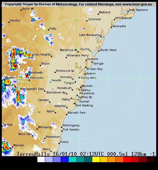
16-1-10, Saturday 6pm: From just after 1pm today Blackheath experienced one of its heaviest thunderstorms in the last decade or more. In the first hour we had 90.7mm, which is a very rare experience for us. Usually storms weaken a little as they move over the Oberon Plateau but not this one. From 1:10pm to 2:35pm I recorded 104mm in total, which is what the BoM reported on their severe weather page after I reported the storm to them earlier today. My house may have been directly under the storm core as Mt Boyce AWS didn't record as much rainfall as I did. There was also lots of lightning which resulted in a blackout for about two hours, starting at about 2pm. Please let me know how much rain you recorded as it would be interesting to know of the varying amounts under this storm. Be sure to check out the Bridal Veil Falls YouTube video I have set up on the photos page, its quite amazing. Has anyone got photos or videos of the falls being heavier than this?
Here are the radar images from around 1pm and 2pm, you can see in the first
image that the initial storm is very focussed on SE Blackheath (over my area)
and Mt Boyce AWS misses out. Then in the second image, further storms are also
occuring over Mt Boyce AWS, just 2 kilometres to the north. This shows well just
how isolated storms can be and also how perfectly positioned these storms were
to flow into Bridal Veil Falls.
Radar
- 16-1-10 - 1pm - click here
Radar
- 16-1-10 - 2pm - click here
Total rainfall for the 24 hours to 9am Sunday morning was 113.5mm. This was more than the whole month of December! It wont be official though as Mt Boyce is the official gauge for this area and it totalled much less.
PS: Just got an email from some folk that were near the bottom of the falls during this flash flood, quite amazing they didn't drown: 'Gee it looks good from the top...spare a thought for myself and my two colleagues, we were at the bottom near the signpost junction to Evens look out sitting down having a break.. It was like someone flushed the toilet and you were in it. The river rose 4 metres and we were lucky to not get washed away. Pretty scary. Didn't see any signs re flash floods. Just not our time yet. We had to wait 1 hour for river to subside for us to cross. Kokoda Buddies.'
3-1-10, Sunday 7:30pm: December came in with 102.5mm from my gauge which is about 30mm above the fourteen year average of Mt Boyce AWS. The official recording for the month from Mt Boyce was 93.4mm. Variations like this are normal due to the scattered nature of summer showers. Average minimum temps came in at 12.2C which is 0.7C above the fourteen year average at Mt Boyce. Average maximum temps came in at 24C, which is 1.4C above the fourteen year average at Mt Boyce. Monthly minimum and maximum averages at Katoomba were 12.5C and 23.9C, which is 0.9C and 1.5C above, respectively. So a pretty warm December and a fairly wet one as well.
Its been quite drizzly and grey so far in January too although rainfall totals have been fairly low thus far. I think there has only been one mainly sunny day since Christmas so a bit more sun would be nice. Tomorrow and Tuesday should be less cloudy and rainy than our recent weather pattern. Happy new year to all weather lovers.